Distance Calculator

Autoestrada do Norte, IC 8

423.4 km, 5 h 22 min

Head southeast on Estrada de Santa Luzia (EM 13-6)1.5 km
Turn left150 m
Continue onto Avenida da Abelheira600 m
Enter the traffic circle and take the 2nd exit onto Via Entre Santos35 m
Exit the traffic circle onto Via Entre Santos450 m
Enter Praça Doutor António Feio Ribeiro da Silva and take the 3rd exit onto Avenida Mateus Carvalhido100 m
Exit the traffic circle onto Avenida Mateus Carvalhido700 m
Enter the traffic circle and take the 1st exit onto Avenida Mateus Carvalhido35 m
Exit the traffic circle onto Avenida Mateus Carvalhido800 m
Enter the traffic circle and take the 2nd exit towards Porto35 m
Exit the traffic circle towards Porto350 m
Keep right towards Porto200 m
Merge left onto A 2870 km
Keep right onto Avenida da Associação Empresarial de Portugal (A 28)200 m
Keep right onto Avenida da Associação Empresarial de Portugal (A 28)150 m
Keep right towards IC 23: Ponte da Arrábida150 m
Merge left onto Via de Cintura Interna (IC 23)7 km
Continue onto Autoestrada do Norte (A 1)100 km
Take the ramp towards A 13-1: Condeixa700 m
Keep right at the fork60 m
Continue onto A 13-110 km
Keep right towards A 13: Tomar400 m
Merge left onto Autoestrada do Pinhal Interior (A 13)20 km
Take exit 24 towards IC 8: Castelo Branco300 m
Keep left towards IC 8: Castelo Branco500 m
Keep right towards Castelo Branco350 m
Merge left onto IC 870 km
Keep left towards A 23600 m
Keep right towards A 23400 m
Merge left onto Autoestrada da Beira Interior (A 23)15 km
Take the ramp towards IP 2: Portalegre600 m
Continue onto IP 245 km
Enter the traffic circle and take the 3rd exit onto IP 270 m
Exit the traffic circle onto IP 21.5 km
Take the ramp on the right towards IP 2: Évora2 km
Take the ramp on the left towards EN 246100 m
Turn left towards EN 246200 m
Enter the traffic circle and take the 2nd exit onto Avenida de Badajoz (EN 246)35 m
Exit the traffic circle onto Avenida de Badajoz (EN 246)300 m
Enter the traffic circle and take the 1st exit onto Avenida de Badajoz (EN 246)35 m
Exit the traffic circle onto Avenida de Badajoz (EN 246)500 m
Enter the traffic circle and take the 2nd exit onto Avenida de Badajoz (EN 246)45 m
Exit the traffic circle onto Avenida de Badajoz (EN 246)700 m
Enter the traffic circle and take the 2nd exit45 m
Exit the traffic circle40 m
Go straight onto EN 2464 km
Enter the traffic circle and take the 1st exit onto EN 24625 m
Exit the traffic circle onto EN 246400 m
Enter the traffic circle and take the 2nd exit onto EN 24630 m
Exit the traffic circle onto EN 24615 km
Make a slight right onto EN 246100 m
Continue onto ER 2461 km
Enter the traffic circle and take the 2nd exit30 m
Exit the traffic circle50 m
Go straight onto ER 2461 km
Enter the traffic circle and take the 2nd exit onto ER 24655 m
Exit the traffic circle onto ER 24610 km
Enter the traffic circle and take the 2nd exit45 m
Exit the traffic circle25 m
Make a slight right onto ER 2461 km
Turn right onto Avenida Coronel Passos e Sousa (ER 246)6 km
Continue onto Rua de Elvas (ER 246)10 km
Enter the traffic circle and take the 1st exit onto ER 2467 m
Exit the traffic circle onto ER 246350 m
Keep left onto ER 246550 m
Keep right onto ER 246100 m
Enter the traffic circle and take the 3rd exit onto Avenida de Badajoz (EN 4)80 m
Exit the traffic circle onto Avenida de Badajoz (EN 4)350 m
Enter the traffic circle and take the 2nd exit onto Avenida de Badajoz (EN 4)45 m
Exit the traffic circle onto Avenida de Badajoz (EN 4)400 m
Enter the traffic circle and take the 2nd exit onto Avenida do Dia de Portugal - 10 de Junho de 2013 (EN 4)40 m
Exit the traffic circle onto Avenida do Dia de Portugal - 10 de Junho de 2013 (EN 4)550 m
Enter the traffic circle and take the 1st exit4 m
Exit the traffic circle1 km
Turn right70 m
You have arrived at your destination, straight ahead0 m
From
    To

      Distance: 214.92 mi (345.88 km)

      Driving route: 263.11 mi (423.44 km).

      Driving time: 5h 22 min

      Distance from Elvas to Viana do Castelo

      The shortest distance (air line) between Elvas and Viana do Castelo is 214.92mi (345.88 km)

      The shortest route between Elvas and Viana do Castelo is 263.11 mi (423.44 km) according to the route planner. The driving time is approx. 5 h 22 m

      How far is it between Elvas and Viana do Castelo.

      Elvas is located in Alto Alentejo, Portugalcountry within 38° 52' 0.12" N -8° 50' 60" W (38.8667, -7.1500) coordinates. The local time in Elvas is 04:47 (19.06.2025)

      Viana do Castelo is located in Alto Minho, Portugalcountry within 41° 42' 0" N -9° 10' 0.12" W (41.7000, -8.8333) coordinates. The local time in Viana do Castelo is 04:47 (19.06.2025)

      The calculated flying distance from Elvas to Viana do Castelo is 214.92miles which is equal to 345.88 km.

      If you want to go by car, the driving driving distance between Elvas and Viana do Castelo is 263.11 miles (423.44 km). If you ride your car with an average speef of 112 kilometers/hour (70 miles/h), travel time will be 3 hours 47 minutes.Please check the avg.speed travel time on the right for various options

      Estimated Travel Time Between Elvas and Viana do Castelo

      Average speedTravel Time
      30 mph (48 km/h)8 hours 46 minutes
      40 mph (64 km/h)6 hours 35 minutes
      50 mph (80 km/h)5 hours 16 minutes
      60 mph (67 km/h)4 hours 23 minutes
      70 mph (112 km/h)3 hours 46 minutes
      75 mph (120 km/h)3 hours 30 minutes

      Elvas, Alto Alentejo, Portugal

      Related Distances from Elvas

      CitiesDistance
      Elvas to Funchal695.25 mi (1,118.89 km)
      Elvas to Setubal96.90 mi (155.95 km)
      Elvas to Leiria107.26 mi (172.62 km)
      Elvas to Lisbon108.14 mi (174.03 km)
      Elvas to Loures108.54 mi (174.68 km)
      Elvas to Almada108.94 mi (175.33 km)
      Elvas to Odivelas109.37 mi (176.02 km)
      Elvas to Amadora112.56 mi (181.14 km)
      Elvas to Queluz114.22 mi (183.82 km)
      Elvas to Coimbra115.21 mi (185.41 km)
      Elvas to Oeiras117.39 mi (188.93 km)
      Elvas to Sintra120.56 mi (194.02 km)
      Elvas to Cascais122.62 mi (197.34 km)
      Elvas to Viseu130.86 mi (210.60 km)
      Elvas to Gondomar173.91 mi (279.88 km)
      Elvas to Vila Nova de Gaia174.78 mi (281.29 km)
      Elvas to Porto176.69 mi (284.35 km)
      Elvas to Matosinhos179.84 mi (289.42 km)
      Elvas to Maia180.98 mi (291.25 km)
      Elvas to Aves187.88 mi (302.36 km)
      Elvas to Guimaraes188.53 mi (303.41 km)
      Elvas to Famalicao190.40 mi (306.41 km)
      Elvas to Braga197.15 mi (317.28 km)
      Elvas to Barcelos198.78 mi (319.91 km)
      Elvas to Viana do Castelo214.92 mi (345.88 km)

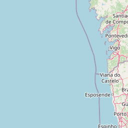
      Viana do Castelo, Alto Minho, Portugal

      Related Distances to Viana do Castelo

      CitiesDistance
      Funchal to Viana do Castelo766.67 mi (1,233.84 km)
      Barcelos to Viana do Castelo16.90 mi (27.20 km)
      Braga to Viana do Castelo23.72 mi (38.17 km)
      Famalicao to Viana do Castelo25.52 mi (41.06 km)
      Guimaraes to Viana do Castelo32.53 mi (52.35 km)
      Aves to Viana do Castelo32.90 mi (52.95 km)
      Maia to Viana do Castelo34.14 mi (54.94 km)
      Matosinhos to Viana do Castelo36.36 mi (58.52 km)
      Porto to Viana do Castelo38.74 mi (62.35 km)
      Vila Nova de Gaia to Viana do Castelo40.73 mi (65.55 km)
      Gondomar to Viana do Castelo41.06 mi (66.07 km)
      Viseu to Viana do Castelo85.84 mi (138.15 km)
      Coimbra to Viana do Castelo105.01 mi (169.00 km)
      Leiria to Viana do Castelo134.74 mi (216.85 km)
      Loures to Viana do Castelo198.85 mi (320.01 km)
      Odivelas to Viana do Castelo201.87 mi (324.88 km)
      Sintra to Viana do Castelo202.55 mi (325.97 km)
      Queluz to Viana do Castelo205.00 mi (329.92 km)
      Amadora to Viana do Castelo206.06 mi (331.62 km)
      Lisbon to Viana do Castelo206.21 mi (331.86 km)
      Almada to Viana do Castelo209.34 mi (336.91 km)
      Cascais to Viana do Castelo209.55 mi (337.24 km)
      Barreiro to Viana do Castelo209.94 mi (337.87 km)
      Oeiras to Viana do Castelo209.99 mi (337.94 km)
      Setubal to Viana do Castelo219.44 mi (353.16 km)