Distance Calculator

La Carolorégienne, R0

80.4 km, 1 h 2 min

Head west on Rue du Bierchamps20 m
Turn right onto Rue des Francs350 m
Turn right onto Rue Léopold Tombelle250 m
Turn left to stay on Rue Léopold Tombelle100 m
Turn right100 m
Turn right45 m
Take the ramp on the right450 m
Merge left onto Petite ceinture de Charleroi (R9)2.5 km
Keep right onto La Carolorégienne (A54)2 km
Keep left onto La Carolorégienne (A54)20 km
Merge left onto E1910 km
Continue onto R020 km
Take the ramp towards U.L.B. Erasme - Erasmus500 m
Keep left at the fork450 m
Merge left onto R05.5 km
Take the ramp200 m
Keep left towards Gent1 km
Merge left onto E4010 km
Take the ramp towards Liedekerke350 m
Turn right onto Molenstraat150 m
Enter the traffic circle and take the 2nd exit onto Molenstraat100 m
Exit the traffic circle onto Molenstraat200 m
Continue onto Stationsstraat (N208)2 km
Enter the traffic circle and take the 2nd exit onto Nijverheidszone Begijnenmeers (N208)55 m
Exit the traffic circle onto Nijverheidszone Begijnenmeers (N208)800 m
Continue onto Thontlaan (N208)350 m
Enter the traffic circle and take the 3rd exit onto Thontlaan100 m
Exit the traffic circle onto Thontlaan250 m
Continue right onto Kiekenborrestraat150 m
Turn left onto Fonteinstraat200 m
Turn left onto Dorp55 m
Turn left to stay on Dorp25 m
Turn right onto Pastorijweg80 m
You have arrived at your destination, on the right0 m
From
    To

      Distance: 36.75 mi (59.14 km)

      Driving route: 49.97 mi (80.42 km).

      Driving time: 1h 1 min

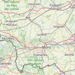
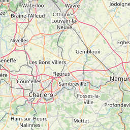
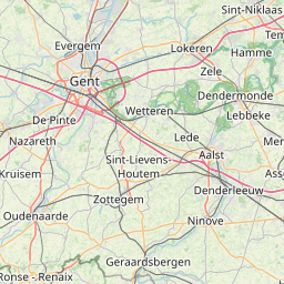
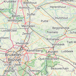
      Distance from Denderleeuw to Charleroi

      The shortest distance (air line) between Denderleeuw and Charleroi is 36.75mi (59.14 km)

      The shortest route between Denderleeuw and Charleroi is 49.97 mi (80.42 km) according to the route planner. The driving time is approx. 1 h 1 m

      How far is it between Denderleeuw and Charleroi.

      Denderleeuw is located in Arr. Aalst, Belgiumcountry within 50° 52' 59.88" N 4° 4' 59.88" E (50.8833, 4.0833) coordinates. The local time in Denderleeuw is 16:37 (18.08.2025)

      Charleroi is located in Arr. Charleroi, Belgiumcountry within 50° 23' 60" N 4° 25' 59.88" E (50.4000, 4.4333) coordinates. The local time in Charleroi is 16:37 (18.08.2025)

      The calculated flying distance from Denderleeuw to Charleroi is 36.75miles which is equal to 59.14 km.

      If you want to go by car, the driving driving distance between Denderleeuw and Charleroi is 49.97 miles (80.42 km). If you ride your car with an average speef of 112 kilometers/hour (70 miles/h), travel time will be 0 hours 43 minutes.Please check the avg.speed travel time on the right for various options

      Estimated Travel Time Between Denderleeuw and Charleroi

      Average speedTravel Time
      30 mph (48 km/h)1 hours 40 minutes
      40 mph (64 km/h)1 hours 15 minutes
      50 mph (80 km/h)0 hours 60 minutes
      60 mph (67 km/h)0 hours 50 minutes
      70 mph (112 km/h)0 hours 43 minutes
      75 mph (120 km/h)0 hours 40 minutes

      Denderleeuw, Arr. Aalst, Belgium

      Related Distances from Denderleeuw

      CitiesDistance
      Denderleeuw to Koekelberg10.96 mi (17.64 km)
      Denderleeuw to Jette10.96 mi (17.64 km)
      Denderleeuw to Moortebeek11.31 mi (18.20 km)
      Denderleeuw to Anderlecht11.44 mi (18.41 km)
      Denderleeuw to Forest11.59 mi (18.66 km)
      Denderleeuw to Laeken11.89 mi (19.13 km)
      Denderleeuw to Brussels12.01 mi (19.33 km)
      Denderleeuw to Sint-Joost-ten-Node13.28 mi (21.38 km)
      Denderleeuw to Etterbeek13.53 mi (21.78 km)
      Denderleeuw to Evere13.86 mi (22.30 km)
      Denderleeuw to Vilvoorde15.18 mi (24.44 km)
      Denderleeuw to Gent19.52 mi (31.42 km)
      Denderleeuw to Mechelen19.97 mi (32.13 km)
      Denderleeuw to Hoboken23.13 mi (37.23 km)
      Denderleeuw to Wilrijk23.52 mi (37.86 km)
      Denderleeuw to Berchem25.29 mi (40.70 km)
      Denderleeuw to Leuven26.88 mi (43.26 km)
      Denderleeuw to Antwerp26.90 mi (43.29 km)
      Denderleeuw to Borgerhout27.49 mi (44.25 km)
      Denderleeuw to Deurne28.77 mi (46.30 km)
      Denderleeuw to Merksem29.30 mi (47.16 km)
      Denderleeuw to Charleroi36.75 mi (59.14 km)
      Denderleeuw to Bruges43.57 mi (70.13 km)
      Denderleeuw to Namur44.78 mi (72.06 km)
      Denderleeuw to Liege67.14 mi (108.06 km)

      Charleroi, Arr. Charleroi, Belgium

      Related Distances to Charleroi

      CitiesDistance
      Namur to Charleroi19.62 mi (31.58 km)
      Forest to Charleroi28.94 mi (46.57 km)
      Etterbeek to Charleroi30.02 mi (48.31 km)
      Anderlecht to Charleroi30.26 mi (48.69 km)
      Brussels to Charleroi31.07 mi (50.00 km)
      Sint-Joost-ten-Node to Charleroi31.17 mi (50.16 km)
      Moortebeek to Charleroi31.69 mi (51.00 km)
      Evere to Charleroi32.28 mi (51.95 km)
      Jette to Charleroi32.54 mi (52.37 km)
      Koekelberg to Charleroi32.54 mi (52.37 km)
      Ganshoren to Charleroi32.65 mi (52.54 km)
      Laeken to Charleroi33.19 mi (53.41 km)
      Leuven to Charleroi35.38 mi (56.94 km)
      Vilvoorde to Charleroi36.49 mi (58.73 km)
      Mechelen to Charleroi43.43 mi (69.89 km)
      Liege to Charleroi52.63 mi (84.71 km)
      Wilrijk to Charleroi53.02 mi (85.33 km)
      Hoboken to Charleroi53.05 mi (85.38 km)
      Berchem to Charleroi54.13 mi (87.11 km)
      Gent to Charleroi54.76 mi (88.12 km)
      Borgerhout to Charleroi56.08 mi (90.26 km)
      Antwerp to Charleroi56.52 mi (90.96 km)
      Deurne to Charleroi57.00 mi (91.73 km)
      Merksem to Charleroi58.23 mi (93.72 km)
      Bruges to Charleroi76.88 mi (123.73 km)