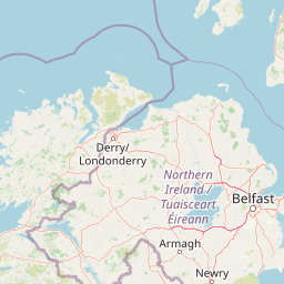
| Head west on Coldingham Place | 200 m |
| Turn right onto St John's Drive | 300 m |
| Turn left onto Garvock Hill | 45 m |
| Turn left onto Appin Crescent (A907) | 450 m |
| Enter Sinclair Gardens Roundabout and take the 1st exit onto St. Margarets Drive (A823) | 4.5 m |
| Exit the traffic circle onto St. Margarets Drive (A823) | 700 m |
| Enter Bothwell Gardens Roundabout and take the 2nd exit onto Bothwell Street (A823) | 40 m |
| Exit the traffic circle onto Bothwell Street (A823) | 200 m |
| Continue onto St Leonard's Street (A823) | 200 m |
| Enter St Leonard Roundabout and take the 1st exit onto Hospital Hill (A823) | 30 m |
| Exit the traffic circle onto Hospital Hill (A823) | 500 m |
| Continue onto Queensferry Road (A823) | 350 m |
| Enter King Malcolm Roundabout and take the 2nd exit onto Queensferry Road (A823) | 60 m |
| Exit the traffic circle onto Queensferry Road (A823) | 1 km |
| Enter St. Margaret Roundabout and take the 2nd exit onto Queensferry Road (A823) | 50 m |
| Exit the traffic circle onto Queensferry Road (A823) | 300 m |
| Enter Pitreavie Roundabout and take the 2nd exit towards A823(M): Kirkcaldy | 60 m |
| Exit the traffic circle towards A823(M): Kirkcaldy | 1.5 km |
| Keep right towards M90 South: Edinburgh | 550 m |
| Merge right onto M90 | 7 km |
| Continue onto A90 | 2 km |
| Keep right towards M90: Glasgow | 3.5 km |
| Keep left towards A8: Airport | 3 km |
| Keep right onto M8 | 8 km |
| Take the ramp on the left towards A899 | 300 m |
| Keep left towards A899 | 600 m |
| Go straight onto Livingston Road (A899) | 4 km |
| Enter Lizzie Brice's Roundabout and take the 3rd exit onto Bankton Road (A71) | 150 m |
| Exit the traffic circle onto Bankton Road (A71) | 2 km |
| Enter Newpark Roundabout and take the 2nd exit onto Bankton Road (A71) | 60 m |
| Exit the traffic circle onto Bankton Road (A71) | 800 m |
| Enter Wilderness Roundabout and take the 1st exit onto Brucefield Park North | 25 m |
| Exit the traffic circle onto Brucefield Park North | 200 m |
| Turn right onto Brucefield Park West | 700 m |
| Continue straight | 2 km |
| Continue straight | 10 km |
| Continue onto Auchengray Road | 1 km |
| Make a slight right | 5 km |
| Turn left onto Carnwath Road (B7016) | 3.5 km |
| Turn right onto A70 | 400 m |
| Make a slight left onto Lampits Road | 1 km |
| Continue onto Carnwath Road | 1 km |
| Turn left onto Pettinain Road | 600 m |
| Continue onto Tie Road No 2 | 2 km |
| Turn right onto Grange Road | 800 m |
| Turn left onto Covington Road | 2.5 km |
| Turn left to stay on Covington Road | 200 m |
| Turn right to stay on Covington Road | 2.5 km |
| Continue onto Boat Road | 600 m |
| Keep left onto Boat Road | 80 m |
| Go straight onto Sherifflats Road | 700 m |
| Turn left onto A73 | 15 km |
| Enter the traffic circle and take the 2nd exit onto A702 | 80 m |
| Exit the traffic circle onto A702 | 1.5 km |
| Enter the traffic circle and take the 2nd exit onto A74(M) | 55 m |
| Exit the traffic circle onto A74(M) | 80 km |
| Continue onto M6 | 60 km |
| Take the ramp on the left onto M6 | 100 km |
| Keep left onto M61 | 35 km |
| Keep right towards M60: Ring Road (W & S) | 800 m |
| Keep left onto M60 | 4.5 km |
| Take the ramp on the left onto M60 | 700 m |
| Keep right towards M60 | 250 m |
| Merge right onto Stretford-Eccles By-Pass (M60) | 500 m |
| Continue onto Barton High Level Bridge (M60) | 5 km |
| Keep right towards Ring Road (S&E) | 10 km |
| Keep right onto M60 | 4.5 km |
| Take the ramp on the left onto M60 | 200 m |
| Keep right onto M60 | 60 m |
| Enter Portwood Roundabout and take the 5th exit onto St. Marys Way (A6188) | 250 m |
| Exit the traffic circle onto St. Marys Way (A6188) | 900 m |
| Keep right onto St. Marys Way (A6188) | 100 m |
| Make a U-turn and continue on St. Marys Way (A6188) | 40 m |
| You have arrived at your destination | 0 m |


 Accedi con Google