Distance Calculator

M6, 6215

77.1 km, 1 h 1 min

Head north on Diósdi út15 m
Make a slight right to stay on Diósdi út250 m
Enter the traffic circle and take the 1st exit onto Budai út10 m
Exit the traffic circle onto Budai út200 m
Continue onto Szabadság tér250 m
Keep left onto Szabadság tér20 m
Make a slight left to stay on Szabadság tér80 m
Continue onto Ercsi út1.5 km
Enter the traffic circle and take the 1st exit towards 7: Martonvásár25 m
Exit the traffic circle towards 7: Martonvásár300 m
Enter the traffic circle and take the 3rd exit towards E 73: Dunaújváros80 m
Exit the traffic circle towards E 73: Dunaújváros300 m
Merge left onto M645 km
Take the ramp towards Újvárosi Pihenőhely|Dunaújváros-centrum400 m
Keep right towards Dunaújváros-centrum500 m
Enter the traffic circle and take the 1st exit onto 62199 m
Exit the traffic circle onto 62199 km
Enter the traffic circle and take the 1st exit4 m
Exit the traffic circle40 m
Continue onto Vörösmarty Mihály utca (6228)550 m
Continue onto József nádor utca (6228)400 m
Continue slightly right onto Fehérvári utca (6228)4 km
Turn left onto 621510 km
Turn left onto Árpád utca (6215)100 m
Turn right onto Túry Miklós utca (6215)700 m
You have arrived at your destination, on the left0 m

M7, 63

84.6 km, 1 h 8 min

Head north on Diósdi út400 m
Enter the traffic circle and take the 2nd exit onto Diósdi út30 m
Exit the traffic circle onto Diósdi út500 m
Enter the traffic circle and take the 2nd exit onto Riminyáki út30 m
Exit the traffic circle onto Riminyáki út1.5 km
Continue onto Bajcsy-Zsilinszky út2.5 km
Enter the traffic circle and take the 2nd exit towards M7: Érd-észak25 m
Exit the traffic circle towards M7: Érd-észak550 m
Take the ramp on the left towards M7: Nagykanizsa350 m
Merge left onto M745 km
Take the ramp towards 63: Székesfehérvár250 m
Keep left towards 63: Szekszárd100 m
Turn left onto 6335 km
Turn left onto Túry Miklós utca (6215)15 m
You have arrived at your destination, on the right0 m
From
    To

      Distance: 36.76 mi (59.16 km)

      Driving route: 47.93 mi (77.13 km).

      Driving time: 1h 1 min

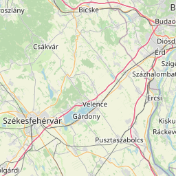
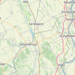
      Distance from Sarbogard to Erd

      The shortest distance (air line) between Sarbogard and Erd is 36.76mi (59.16 km)

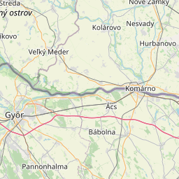
      The shortest route between Sarbogard and Erd is 47.93 mi (77.13 km) according to the route planner. The driving time is approx. 1 h 1 m

      How far is it between Sarbogard and Erd.

      Sarbogard is located in Fejer, Hungarycountry within 46° 53' 16.08" N 18° 37' 9.48" E (46.8878, 18.6193) coordinates. The local time in Sarbogard is 12:39 (22.06.2025)

      Erd is located in Pest, Hungarycountry within 47° 22' 42.24" N 18° 55' 19.2" E (47.3784, 18.9220) coordinates. The local time in Erd is 12:39 (22.06.2025)

      The calculated flying distance from Sarbogard to Erd is 36.76miles which is equal to 59.16 km.

      If you want to go by car, the driving driving distance between Sarbogard and Erd is 47.93 miles (77.13 km). If you ride your car with an average speef of 112 kilometers/hour (70 miles/h), travel time will be 0 hours 41 minutes.Please check the avg.speed travel time on the right for various options

      Estimated Travel Time Between Sarbogard and Erd

      Average speedTravel Time
      30 mph (48 km/h)1 hours 36 minutes
      40 mph (64 km/h)1 hours 12 minutes
      50 mph (80 km/h)0 hours 58 minutes
      60 mph (67 km/h)0 hours 48 minutes
      70 mph (112 km/h)0 hours 41 minutes
      75 mph (120 km/h)0 hours 38 minutes

      Sarbogard, Fejer, Hungary

      Related Distances from Sarbogard

      CitiesDistance
      Sarbogard to Dunaujvaros15.26 mi (24.55 km)
      Sarbogard to Szekesfehervar23.46 mi (37.76 km)
      Sarbogard to Szigethalom34.74 mi (55.91 km)
      Sarbogard to Veszprem36.15 mi (58.17 km)
      Sarbogard to Erd36.76 mi (59.16 km)
      Sarbogard to Szekszard36.96 mi (59.48 km)
      Sarbogard to Szigetszentmiklos37.51 mi (60.37 km)
      Sarbogard to Budapest46.45 mi (74.75 km)
      Sarbogard to Tatabanya49.39 mi (79.48 km)
      Sarbogard to Kecskemet50.55 mi (81.35 km)
      Sarbogard to Kaposvar53.74 mi (86.49 km)
      Sarbogard to Dunakeszi56.84 mi (91.47 km)
      Sarbogard to Pecs59.36 mi (95.54 km)
      Sarbogard to Szolnok76.87 mi (123.72 km)
      Sarbogard to Nagykanizsa82.72 mi (133.12 km)
      Sarbogard to Zalaegerszeg83.60 mi (134.54 km)
      Sarbogard to Szeged84.63 mi (136.20 km)
      Sarbogard to Hodmezovasarhely86.57 mi (139.31 km)
      Sarbogard to Szombathely97.02 mi (156.14 km)
      Sarbogard to Salgotarjan100.68 mi (162.04 km)
      Sarbogard to Eger107.80 mi (173.49 km)
      Sarbogard to Bekescsaba117.82 mi (189.62 km)
      Sarbogard to Miskolc126.33 mi (203.31 km)
      Sarbogard to Debrecen148.52 mi (239.01 km)
      Sarbogard to Nyiregyhaza162.85 mi (262.08 km)

      Erd, Pest, Hungary

      Related Distances to Erd

      CitiesDistance
      Szigethalom to Erd5.92 mi (9.53 km)
      Szigetszentmiklos to Erd6.33 mi (10.19 km)
      Budapest to Erd9.94 mi (15.99 km)
      Dunakeszi to Erd20.19 mi (32.49 km)
      Szekesfehervar to Erd27.16 mi (43.71 km)
      Dunaujvaros to Erd27.49 mi (44.24 km)
      Tatabanya to Erd28.49 mi (45.86 km)
      Cegled to Erd43.60 mi (70.16 km)
      Kecskemet to Erd48.65 mi (78.29 km)
      Veszprem to Erd51.24 mi (82.47 km)
      Szolnok to Erd61.38 mi (98.78 km)
      Salgotarjan to Erd64.85 mi (104.37 km)
      Szekszard to Erd71.39 mi (114.89 km)
      Eger to Erd76.60 mi (123.28 km)
      Kaposvar to Erd88.39 mi (142.24 km)
      Hodmezovasarhely to Erd92.94 mi (149.57 km)
      Miskolc to Erd94.58 mi (152.21 km)
      Pecs to Erd96.06 mi (154.59 km)
      Szeged to Erd96.79 mi (155.77 km)
      Zalaegerszeg to Erd104.26 mi (167.80 km)
      Szombathely to Erd108.21 mi (174.15 km)
      Nagykanizsa to Erd111.18 mi (178.93 km)
      Bekescsaba to Erd113.00 mi (181.86 km)
      Debrecen to Erd127.37 mi (204.98 km)
      Nyiregyhaza to Erd136.42 mi (219.55 km)