


Distance Calculator

Distance from Trstenik to Kikinda
The shortest distance (air line) between Trstenik and Kikinda is 155.36mi (250.03 km)
The shortest route between Trstenik and Kikinda is 242.68 mi (390.55 km) according to the route planner. The driving time is approx. 4 h 40 m
How far is it between Trstenik and Kikinda.
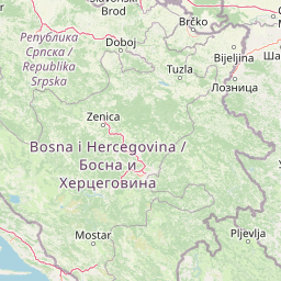
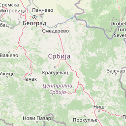
Trstenik is located in Rasinska oblast, Serbiacountry within 43° 37' 6.96" N 20° 59' 49.92" E (43.6186, 20.9972) coordinates. The local time in Trstenik is 08:07 (03.09.2025)
Kikinda is located in Severnobanatska oblast, Serbiacountry within 45° 49' 59.88" N 20° 26' 60" E (45.8333, 20.4500) coordinates. The local time in Kikinda is 08:07 (03.09.2025)
The calculated flying distance from Trstenik to Kikinda is 155.36miles which is equal to 250.03 km.
If you want to go by car, the driving driving distance between Trstenik and Kikinda is 242.68 miles (390.55 km). If you ride your car with an average speef of 112 kilometers/hour (70 miles/h), travel time will be 3 hours 29 minutes.Please check the avg.speed travel time on the right for various options
Estimated Travel Time Between Trstenik and Kikinda
| Average speed | Travel Time |
|---|---|
| 30 mph (48 km/h) | 8 hours 5 minutes |
| 40 mph (64 km/h) | 6 hours 4 minutes |
| 50 mph (80 km/h) | 4 hours 51 minutes |
| 60 mph (67 km/h) | 4 hours 3 minutes |
| 70 mph (112 km/h) | 3 hours 28 minutes |
| 75 mph (120 km/h) | 3 hours 14 minutes |
Trstenik, Rasinska oblast, Serbia
Related Distances from Trstenik
| Cities | Distance |
|---|---|
| Trstenik to Krusevac | 16.67 mi (26.82 km) |
| Trstenik to Kraljevo | 17.11 mi (27.54 km) |
| Trstenik to Kragujevac | 27.48 mi (44.23 km) |
| Trstenik to Cuprija | 28.04 mi (45.12 km) |
| Trstenik to Novi Pazar | 40.38 mi (64.98 km) |
| Trstenik to Nis | 49.59 mi (79.81 km) |
| Trstenik to Uzice | 59.46 mi (95.69 km) |
| Trstenik to Bor | 65.47 mi (105.37 km) |
| Trstenik to Prijepolje | 67.56 mi (108.72 km) |
| Trstenik to Valjevo | 71.25 mi (114.66 km) |
| Trstenik to Bajina Basta | 75.76 mi (121.92 km) |
| Trstenik to Kovin | 78.19 mi (125.83 km) |
| Trstenik to Belgrade | 87.17 mi (140.28 km) |
| Trstenik to Pancevo | 88.29 mi (142.09 km) |
| Trstenik to Zemun | 90.07 mi (144.96 km) |
| Trstenik to Pecinci | 102.17 mi (164.43 km) |
| Trstenik to Stara Pazova | 102.85 mi (165.51 km) |
| Trstenik to Vrsac | 104.61 mi (168.35 km) |
| Trstenik to Indija | 108.72 mi (174.97 km) |
| Trstenik to Ruma | 111.45 mi (179.36 km) |
| Trstenik to Sremska Mitrovica | 115.79 mi (186.34 km) |
| Trstenik to Zrenjanin | 125.55 mi (202.06 km) |
| Trstenik to Sid | 135.29 mi (217.72 km) |
| Trstenik to Kikinda | 155.36 mi (250.03 km) |
| Trstenik to Senta | 165.88 mi (266.95 km) |
Kikinda, Severnobanatska oblast, Serbia
Related Distances to Kikinda
| Cities | Distance |
|---|---|
| Senta to Kikinda | 18.59 mi (29.93 km) |
| Zrenjanin to Kikinda | 31.23 mi (50.26 km) |
| Indija to Kikinda | 56.97 mi (91.68 km) |
| Stara Pazova to Kikinda | 60.32 mi (97.07 km) |
| Vrsac to Kikinda | 64.50 mi (103.81 km) |
| Ruma to Kikinda | 64.88 mi (104.41 km) |
| Pancevo to Kikinda | 67.15 mi (108.08 km) |
| Zemun to Kikinda | 67.98 mi (109.41 km) |
| Pecinci to Kikinda | 68.62 mi (110.43 km) |
| Belgrade to Kikinda | 70.01 mi (112.68 km) |
| Sremska Mitrovica to Kikinda | 72.17 mi (116.15 km) |
| Sid to Kikinda | 76.98 mi (123.89 km) |
| Kovin to Kikinda | 78.95 mi (127.06 km) |
| Valjevo to Kikinda | 111.72 mi (179.80 km) |
| Kragujevac to Kikinda | 127.95 mi (205.91 km) |
| Bajina Basta to Kikinda | 135.71 mi (218.40 km) |
| Cuprija to Kikinda | 139.43 mi (224.39 km) |
| Uzice to Kikinda | 140.15 mi (225.55 km) |
| Bor to Kikinda | 142.74 mi (229.71 km) |
| Kraljevo to Kikinda | 146.24 mi (235.35 km) |
| Trstenik to Kikinda | 155.36 mi (250.03 km) |
| Krusevac to Kikinda | 161.31 mi (259.60 km) |
| Prijepolje to Kikinda | 162.97 mi (262.28 km) |
| Novi Pazar to Kikinda | 185.43 mi (298.42 km) |
| Nis to Kikinda | 187.71 mi (302.10 km) |
 Accedi con Google