Distance Calculator

Autostrada București-Pitești, DN14

361.5 km, 5 h 54 min

Head north on Bulevardul Ion Constantin Brătianu (DN4)150 m
Continue onto Bulevardul Ion C. Brătianu (DN4)200 m
Enter Piața Universității and take the 3rd exit onto Bulevardul Regina Elisabeta60 m
Exit the traffic circle onto Bulevardul Regina Elisabeta1 km
Go straight onto Bulevardul Mihail Kogălniceanu700 m
Go straight onto Splaiul Independenței900 m
Turn left onto Podul Cotroceni60 m
Continue onto Șoseaua Cotroceni900 m
Continue onto Bulevardul Iuliu Maniu7 km
Continue towards Pitești100 km
Continue onto Autostrada Sibiu-Pitești (A1)15 km
Enter the traffic circle and take the 1st exit onto DN7C4 m
Exit the traffic circle onto DN7C1 km
Turn left towards DJ704H: Vâlcele2 km
Turn right onto DJ704H3.5 km
Turn left onto DJ704H8 km
Turn left to stay on Strada Luncilor (DJ704H)2 km
Continue slightly right onto Strada Bușaga (DJ704H)200 m
Turn left onto Strada Râmnicu Vâlcea (DN73C)4.5 km
Continue onto Strada Argeșului (DN73C)5 km
Make a slight right onto Strada Principală3 km
Continue onto DJ678A10 km
Turn left onto DJ703G4.5 km
Make a slight right to stay on Strada Principală (DJ703G)7 km
Turn right onto Strada Principală Brădișor (DJ703N)10 km
Continue onto DC14A150 m
Continue onto Strada Principală (DJ703H)2 km
Turn left onto Strada Băiașu (DJ703M)7 km
Continue onto Strada Izlazului (DJ703M)3.5 km
Turn left onto DN79 km
Continue straight to stay on Strada Principală (DN7)8 km
Enter the traffic circle and take the 1st exit onto DN720 m
Exit the traffic circle onto DN715 km
Enter the traffic circle and take the 2nd exit150 m
Exit the traffic circle1 km
Continue onto Autostrada Sibiu-Pitești (A1)20 km
Take the ramp towards DN14: Mediaș1 km
Enter the traffic circle and take the 1st exit onto DN145 m
Exit the traffic circle onto DN1445 km
Enter the traffic circle and take the 1st exit onto DN1425 m
Exit the traffic circle onto DN14550 m
Turn right onto Șoseaua Sibiului (DN14)1 km
Turn left onto Strada Gării700 m
Enter the traffic circle and take the 2nd exit onto Strada Gării30 m
Exit the traffic circle onto Strada Gării100 m
Continue onto Strada Titus Andronic800 m
Continue slightly right onto Strada 1 Decembrie 1918450 m
Make a slight right onto Strada 1 Decembrie 1918800 m
Turn left onto Strada Baznei (DN14A)1 km
Turn right to stay on Strada Baznei (DN14A)20 km
Continue onto Strada Armatei2.5 km
Continue onto Strada Doctor Victor Babeş450 m
Enter the traffic circle and take the 3rd exit towards Târgu Mureș30 m
Exit the traffic circle towards Târgu Mureș300 m
Continue slightly left onto Strada Republicii (DN14A)450 m
Enter the traffic circle and take the 1st exit towards Târgu Mureș4.5 m
Exit the traffic circle towards Târgu Mureș900 m
Turn right onto Strada Petru Maior150 m
Turn left onto Strada 8 Martie250 m
Turn left onto Strada Viticultorilor35 m
Turn right onto Strada 22 Decembrie200 m
Continue onto DN14A9 km
Turn right200 m
Keep left at the fork100 m
Continue straight200 m
Turn left150 m
Make a slight right350 m
Turn left150 m
Turn right onto DN14A2.5 km
Enter the traffic circle and take the 2nd exit onto DN14A80 m
Exit the traffic circle onto DN14A1 km
Enter the traffic circle and take the 1st exit onto Strada Câmpului (DN14A)50 m
Exit the traffic circle onto Strada Câmpului (DN14A)1 km
Make a slight left100 m
Go straight onto DN151.5 km
Turn right onto Piața 1 Decembrie 1918 (DJ152A)250 m
Make a slight left onto Strada Horea150 m
You have arrived at your destination, on the right0 m

DN1, DN13

379.8 km, 5 h 60 min

Head north on Bulevardul Ion Constantin Brătianu (DN4)150 m
Continue onto Bulevardul Ion C. Brătianu (DN4)200 m
Exit the traffic circle onto Bulevardul Carol I (DN2)250 m
Continue onto Piața C. A. Rosetti (DN2)150 m
Continue onto Bulevardul Carol I (DN2)600 m
Turn left onto Calea Moșilor (DN2)1.5 km
Continue onto Șoseaua Colentina (DN2)2.5 km
Turn left onto Strada Gherghiței1 km
Make a slight left to stay on Strada Gherghiței40 m
Enter the traffic circle and take the 2nd exit towards Brașov45 m
Exit the traffic circle towards Brașov45 km
Keep left onto A315 km
Enter the traffic circle and take the 2nd exit towards DN1: Brașov80 m
Exit the traffic circle towards DN1: Brașov5 km
Enter the traffic circle and take the 1st exit towards DN1: Oradea35 m
Exit the traffic circle towards DN1: Oradea1.5 km
Enter the traffic circle and take the 2nd exit towards DN1: Brașov40 m
Exit the traffic circle towards DN1: Brașov5 km
Enter the traffic circle and take the 2nd exit towards DN1: Oradea50 m
Exit the traffic circle towards DN1: Oradea2.5 km
Enter the traffic circle and take the 2nd exit onto DN120 m
Exit the traffic circle onto DN110 km
Enter the traffic circle and take the 1st exit onto DN115 m
Exit the traffic circle onto DN115 km
Enter the traffic circle and take the 3rd exit towards Brașov55 m
Exit the traffic circle towards Brașov25 km
Enter the traffic circle and take the 1st exit onto Calea București (DN1)15 m
Exit the traffic circle onto Calea București (DN1)900 m
Turn right150 m
Keep left at the fork300 m
Merge left onto Calea București (DN1)700 m
Continue onto Calea Prahovei (DN1)800 m
Enter the traffic circle and take the 1st exit onto Calea Prahovei (DN1)40 m
Exit the traffic circle onto Calea Prahovei (DN1)800 m
Continue onto Strada Gării (DN1)450 m
Continue onto Calea Brașovului (DN1)1.5 km
Enter the traffic circle and take the 1st exit onto Bulevardul Ferdinand (DN1)45 m
Exit the traffic circle onto Bulevardul Ferdinand (DN1)1 km
Continue onto Bulevardul Independenței (DN1)2.5 km
Continue onto Bulevardul Libertății (DN1)10 km
Continue onto Bulevardul Mihail Săulescu (DN1)3 km
Turn right onto DN120 km
Take the ramp towards DN13: Târgu Mureș150 m
Merge left onto Strada Timișul Sec (DN1K)600 m
Continue onto Centura Brașov (DN1K)1.5 km
Enter the traffic circle and take the 2nd exit towards DNVO1K: Târgu Mureș35 m
Exit the traffic circle towards DNVO1K: Târgu Mureș10 km
Take the ramp towards DN13: Brașov150 m
Continue towards Brașov150 m
Keep right towards DN13: Târgu Mureș60 m
Merge left onto Calea Feldioarei (DN13)1.5 km
Keep right onto Calea Feldioarei7 km
Continue onto DN13500 m
Make a slight right55 m
Enter the traffic circle and take the 2nd exit towards Târgu Mureș45 m
Exit the traffic circle towards Târgu Mureș55 m
Continue onto DN1345 km
Make a slight right350 m
Merge left onto DN137 km
Keep left at the fork200 m
Merge left onto DN1330 km
Turn right900 m
Make a slight right200 m
Turn right100 m
Turn right onto Strada Principală (DN13)20 km
Continue onto Strada Consiliul Europei (DN13)1 km
Continue onto Strada Morii (DN13)200 m
Continue onto Strada Zaharia Boiu (DN13)700 m
Continue onto Strada Cornești (DN13)1 km
Enter the traffic circle and take the 1st exit towards DN13: Târgu Mureș10 m
Exit the traffic circle towards DN13: Târgu Mureș30 km
Enter the traffic circle and take the 2nd exit onto DN13100 m
Exit the traffic circle onto DN1310 km
Make a sharp left onto DJ151D10 km
Make a slight right onto DJ151D4 km
Take the ramp towards A3550 m
Merge left onto Autostrada Transilvania (A3)15 km
Take the ramp towards DN14A: Mediaș2 km
Enter the traffic circle and take the 1st exit onto DN14A50 m
Exit the traffic circle onto DN14A1 km
Enter the traffic circle and take the 1st exit onto Strada Câmpului (DN14A)50 m
Exit the traffic circle onto Strada Câmpului (DN14A)1 km
Make a slight left100 m
Go straight onto DN151.5 km
Turn right onto Piața 1 Decembrie 1918 (DJ152A)250 m
Make a slight left onto Strada Horea150 m
You have arrived at your destination, on the right0 m
From
    To

      Distance: 166.49 mi (267.94 km)

      Driving route: 224.64 mi (361.52 km).

      Driving time: 5h 53 min

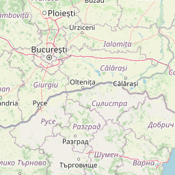
      Distance from Iernut to Bucharest

      The shortest distance (air line) between Iernut and Bucharest is 166.49mi (267.94 km)

      The shortest route between Iernut and Bucharest is 224.64 mi (361.52 km) according to the route planner. The driving time is approx. 5 h 53 m

      How far is it between Iernut and Bucharest.

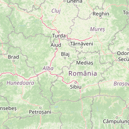
      Iernut is located in Mures, Romaniacountry within 46° 27' 12.96" N 24° 13' 59.88" E (46.4536, 24.2333) coordinates. The local time in Iernut is 03:35 (04.06.2025)

      Bucharest is located in Bucuresti, Romaniacountry within 44° 25' 57" N 26° 6' 14.04" E (44.4325, 26.1039) coordinates. The local time in Bucharest is 03:35 (04.06.2025)

      The calculated flying distance from Iernut to Bucharest is 166.49miles which is equal to 267.94 km.

      If you want to go by car, the driving driving distance between Iernut and Bucharest is 224.64 miles (361.52 km). If you ride your car with an average speef of 112 kilometers/hour (70 miles/h), travel time will be 3 hours 14 minutes.Please check the avg.speed travel time on the right for various options

      Estimated Travel Time Between Iernut and Bucharest

      Average speedTravel Time
      30 mph (48 km/h)7 hours 29 minutes
      40 mph (64 km/h)5 hours 37 minutes
      50 mph (80 km/h)4 hours 30 minutes
      60 mph (67 km/h)3 hours 45 minutes
      70 mph (112 km/h)3 hours 13 minutes
      75 mph (120 km/h)2 hours 60 minutes

      Iernut, Mures, Romania

      Related Distances from Iernut

      CitiesDistance
      Iernut to Targu-Mures16.90 mi (27.20 km)
      Iernut to Cluj-Napoca37.68 mi (60.64 km)
      Iernut to Alba Iulia41.45 mi (66.70 km)
      Iernut to Sibiu45.82 mi (73.74 km)
      Iernut to Brasov85.76 mi (138.02 km)
      Iernut to Baia Mare89.23 mi (143.59 km)
      Iernut to Ramnicu Valcea93.45 mi (150.40 km)
      Iernut to Targu Jiu108.42 mi (174.48 km)
      Iernut to Satu Mare111.86 mi (180.03 km)
      Iernut to Pitesti114.25 mi (183.87 km)
      Iernut to Oradea117.48 mi (189.07 km)
      Iernut to Suceava126.14 mi (203.00 km)
      Iernut to Ploiesti135.55 mi (218.15 km)
      Iernut to Resita138.04 mi (222.16 km)
      Iernut to Slatina139.98 mi (225.28 km)
      Iernut to Arad140.70 mi (226.44 km)
      Iernut to Botosani145.36 mi (233.94 km)
      Iernut to Craiova147.89 mi (238.00 km)
      Iernut to Focsani150.50 mi (242.21 km)
      Iernut to Timisoara151.64 mi (244.03 km)
      Iernut to Iasi166.05 mi (267.24 km)
      Iernut to Bucharest166.49 mi (267.94 km)
      Iernut to Vaslui166.60 mi (268.12 km)
      Iernut to Giurgiu195.68 mi (314.92 km)
      Iernut to Tulcea236.54 mi (380.68 km)

      Bucharest, Bucuresti, Romania

      Related Distances to Bucharest

      CitiesDistance
      Ploiesti to Bucharest35.37 mi (56.92 km)
      Giurgiu to Bucharest37.30 mi (60.02 km)
      Pitesti to Bucharest67.58 mi (108.76 km)
      Slatina to Bucharest85.83 mi (138.14 km)
      Brasov to Bucharest88.53 mi (142.47 km)
      Ramnicu Valcea to Bucharest96.66 mi (155.57 km)
      Focsani to Bucharest102.10 mi (164.32 km)
      Craiova to Bucharest113.15 mi (182.09 km)
      Sibiu to Bucharest133.76 mi (215.26 km)
      Tulcea to Bucharest142.13 mi (228.74 km)
      Targu Jiu to Bucharest144.95 mi (233.27 km)
      Targu-Mures to Bucharest163.98 mi (263.89 km)
      Alba Iulia to Bucharest167.15 mi (269.00 km)
      Vaslui to Bucharest171.50 mi (276.00 km)
      Hunedoara to Bucharest180.65 mi (290.73 km)
      Iasi to Bucharest201.70 mi (324.61 km)
      Cluj-Napoca to Bucharest202.11 mi (325.27 km)
      Resita to Bucharest214.91 mi (345.86 km)
      Suceava to Bucharest222.52 mi (358.12 km)
      Botosani to Bucharest230.72 mi (371.30 km)
      Baia Mare to Bucharest254.02 mi (408.81 km)
      Timisoara to Bucharest254.74 mi (409.97 km)
      Arad to Bucharest262.07 mi (421.76 km)
      Oradea to Bucharest271.83 mi (437.46 km)
      Satu Mare to Bucharest278.36 mi (447.97 km)