


Distance Calculator


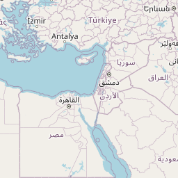


Distance from Aarhus to Istanbul
The shortest distance (air line) between Aarhus and Istanbul is 1,343.22mi (2,161.71 km)
The shortest route between Aarhus and Istanbul is 1749.80 mi (2816.03 km) according to the route planner. The driving time is approx. 28 h 17 m
How far is it between Aarhus and Istanbul.
Aarhus is located in Ostjylland, Denmarkcountry within 56° 9' 25.92" N 10° 12' 38.52" E (56.1572, 10.2107) coordinates. The local time in Aarhus is 22:35 (08.10.2025)
Istanbul is located in Istanbul, Turkeycountry within 41° 0' 48.96" N 28° 57' 18" E (41.0136, 28.9550) coordinates. The local time in Istanbul is 00:35 (09.10.2025)
The calculated flying distance from Aarhus to Istanbul is 1,343.22miles which is equal to 2,161.71 km.
If you want to go by car, the driving driving distance between Aarhus and Istanbul is 1749.80 miles (2816.03 km). If you ride your car with an average speef of 112 kilometers/hour (70 miles/h), travel time will be 25 hours 9 minutes.Please check the avg.speed travel time on the right for various options
Estimated Travel Time Between Aarhus and Istanbul
| Average speed | Travel Time |
|---|---|
| 30 mph (48 km/h) | 58 hours 20 minutes |
| 40 mph (64 km/h) | 43 hours 45 minutes |
| 50 mph (80 km/h) | 34 hours 60 minutes |
| 60 mph (67 km/h) | 29 hours 10 minutes |
| 70 mph (112 km/h) | 24 hours 60 minutes |
| 75 mph (120 km/h) | 23 hours 20 minutes |
Related Distances from Aarhus
| Cities | Distance |
|---|---|
| Aarhus to Randers | 21.73 mi (34.98 km) |
| Aarhus to Horsens | 24.91 mi (40.09 km) |
| Aarhus to Silkeborg | 25.41 mi (40.90 km) |
| Aarhus to Viborg | 36.47 mi (58.69 km) |
| Aarhus to Vejle | 40.17 mi (64.65 km) |
| Aarhus to Fredericia | 44.54 mi (71.68 km) |
| Aarhus to Herning | 47.27 mi (76.08 km) |
| Aarhus to Odense | 53.06 mi (85.39 km) |
| Aarhus to Kolding | 53.62 mi (86.29 km) |
| Aarhus to Aalborg | 62.69 mi (100.89 km) |
| Aarhus to Holstebro | 62.77 mi (101.02 km) |
| Aarhus to Norresundby | 63.83 mi (102.72 km) |
| Aarhus to Holbaek | 65.98 mi (106.19 km) |
| Aarhus to Slagelse | 68.35 mi (110.00 km) |
| Aarhus to Soro | 72.63 mi (116.89 km) |
| Aarhus to Roskilde | 80.55 mi (129.63 km) |
| Aarhus to Esbjerg | 82.69 mi (133.08 km) |
| Aarhus to Hillerod | 82.73 mi (133.14 km) |
| Aarhus to Sonderborg | 87.45 mi (140.74 km) |
| Aarhus to Taastrup | 88.18 mi (141.91 km) |
| Aarhus to Naestved | 88.21 mi (141.95 km) |
| Aarhus to Koge | 90.50 mi (145.65 km) |
| Aarhus to Horsholm | 90.76 mi (146.06 km) |
| Aarhus to Helsingor | 92.78 mi (149.31 km) |
| Aarhus to Copenhagen | 97.14 mi (156.34 km) |
Related Distances to Istanbul
| Cities | Distance |
|---|---|
| Erzurum to Istanbul | 651.68 mi (1,048.78 km) |
| Esenler to Istanbul | 3.65 mi (5.88 km) |
| Kagithane to Istanbul | 4.07 mi (6.55 km) |
| Bagcilar to Istanbul | 5.34 mi (8.59 km) |
| Kucukcekmece to Istanbul | 8.14 mi (13.09 km) |
| Kartal to Istanbul | 15.06 mi (24.23 km) |
| Esenyurt to Istanbul | 15.65 mi (25.19 km) |
| Pendik to Istanbul | 17.48 mi (28.14 km) |
| Bursa to Istanbul | 57.58 mi (92.67 km) |
| Yildirim to Istanbul | 62.79 mi (101.05 km) |
| Eskisehir to Istanbul | 118.70 mi (191.03 km) |
| Izmir to Istanbul | 203.50 mi (327.50 km) |
| Ankara to Istanbul | 217.96 mi (350.77 km) |
| Cankaya to Istanbul | 219.86 mi (353.83 km) |
| Denizli to Istanbul | 224.44 mi (361.21 km) |
| Selcuklu to Istanbul | 287.09 mi (462.03 km) |
| Konya to Istanbul | 287.56 mi (462.78 km) |
| Antalya to Istanbul | 300.22 mi (483.16 km) |
| Kayseri to Istanbul | 380.74 mi (612.75 km) |
| Samsun to Istanbul | 384.23 mi (618.36 km) |
| Mersin to Istanbul | 421.68 mi (678.62 km) |
| Adana to Istanbul | 439.94 mi (708.01 km) |
| Seyhan to Istanbul | 441.18 mi (710.02 km) |
| Gaziantep to Istanbul | 527.75 mi (849.33 km) |
| Akcaabat to Istanbul | 552.01 mi (888.38 km) |
 Log in with Google