


Distance Calculator


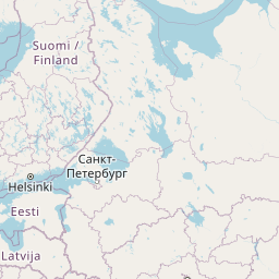


A1, Autostrada Bursztynowa
3389.0 km, 39 h
| Head southeast on Ruotsinsalmenkatu | 35 m | |
| Turn right onto Kirkkokatu | 450 m | |
| Turn right onto Kotkankatu | 150 m | |
| Turn left onto Rautatienkatu (15) | 400 m | |
| Continue onto Hyväntuulentie (15) | 5.5 km | |
| Turn left | 550 m | |
| Merge left onto Valtatie 7 (7) | 25 km | |
| Continue onto Ahvenkosken silta (7) | 400 m | |
| Continue onto Ohikulkutie (7) | 15 km | |
| Continue onto Porvoon Moottoritie (7) | 20 km | |
| Continue onto Valtatie 7 (7) | 30 km | |
| Continue onto Porvoonväylä (7) | 25 km | |
| Merge left onto Lahdenväylä (4) | 6 km | |
| Continue onto Kustaa Vaasan tie | 1.5 km | |
| Continue onto Hämeentie | 150 m | |
| Keep left onto Hämeentie | 550 m | |
| Keep right onto Sturenkatu | 2 km | |
| Continue onto Helsinginkatu | 900 m | |
| Continue onto Runeberginkatu | 800 m | |
| Keep right onto Caloniuksenkatu | 250 m | |
| Turn left onto Mechelininkatu | 1.5 km | |
| Turn right towards Jätkäsaari | 250 m | |
| Go straight onto Tyynenmerenkatu | 400 m | |
| Turn left onto Rionkatu | 50 m | |
| Turn right | 800 m | |
| Make a slight left | 150 m | |
| Take the ferry Helsinki–Tallinn | 80 km | |
| Make a slight left | 150 m | |
| Turn left | 350 m | |
| Continue onto Petrooleumi | 450 m | |
| Continue slightly left onto Jüri Vilmsi | 1 km | |
| Turn right onto Konstantin Türnpu | 300 m | |
| Turn right onto Odra | 300 m | |
| Continue onto Filtri tee | 700 m | |
| Make a slight right towards Veerenni tn | 100 m | |
| Make a slight left towards Luite | 150 m | |
| Turn left onto Veskiposti | 200 m | |
| Enter the traffic circle and take the 3rd exit towards Järvevana tee | 80 m | |
| Exit the traffic circle towards Järvevana tee | 400 m | |
| Go straight onto Järvevana tee | 2.5 km | |
| Go straight towards 4: Pärnu | 300 m | |
| Make a slight right onto Pärnu mnt (4) | 1.5 km | |
| Continue onto Männiku tee (4) | 450 m | |
| Go straight onto Vabaduse pst (4) | 6 km | |
| Continue onto Pärnu mnt (4) | 1 km | |
| Make a slight right onto Veskitammi (11401) | 60 m | |
| Make a slight left to stay on Veskitammi (11401) | 150 m | |
| Make a slight right | 150 m | |
| Merge left onto Pärnu mnt (4) | 1.5 km | |
| Continue onto Tallinn — Pärnu — Ikla (4) | 100 km | |
| Continue onto Pärnu mnt (4) | 2 km | |
| Continue onto Tallinn — Pärnu — Ikla (4) | 9 km | |
| Continue onto Tallinna mnt (4) | 1.5 km | |
| Enter the traffic circle and take the 2nd exit onto Tallinna mnt (4) | 45 m | |
| Exit the traffic circle onto Tallinna mnt (4) | 600 m | |
| Continue onto Tallinn — Pärnu — Ikla (4) | 1.5 km | |
| Continue onto Tuisu (4) | 600 m | |
| Continue slightly left onto Ehitajate tee (4) | 5 km | |
| Continue onto Papiniidu (4) | 400 m | |
| Go straight onto Liivi tee (4) | 1.5 km | |
| Continue straight to stay on Liivi tee (4) | 700 m | |
| Continue left onto Riia mnt (4) | 450 m | |
| Make a slight left onto Paide mnt (59) | 50 m | |
| Turn right to stay on Riia mnt (4) | 1 km | |
| Continue onto Tallinn — Pärnu — Ikla (4) | 15 km | |
| Continue onto Riia mnt (4) | 3.5 km | |
| Continue onto Tallinn — Pärnu — Ikla (4) | 35 km | |
| Continue onto Rīga (Baltezers) — Igaunijas robeža (Ainaži) (A1) | 9 km | |
| Continue onto Pērnavas iela (A1) | 4 km | |
| Continue onto Viļņu iela (A1) | 1 km | |
| Continue onto Rīga (Baltezers) — Igaunijas robeža (Ainaži) (A1) | 550 m | |
| Continue onto Vidzemes iela (A1) | 2.5 km | |
| Continue onto Rīga (Baltezers) — Igaunijas robeža (Ainaži) (A1) | 80 km | |
| Continue onto Tallinas šoseja (A1) | 2 km | |
| Continue onto Cielaviņu iela (A1) | 250 m | |
| Continue onto Rīga (Baltezers) — Igaunijas robeža (Ainaži) (A1) | 2.5 km | |
| Continue onto A4 | 20 km | |
| Take the ramp onto A4 | 500 m | |
| Merge left onto Rīga — Daugavpils — Krāslava — Baltkrievijas robeža (Pāternieki) (A6) | 2.5 km | |
| Continue onto Ķesterciema iela (A6) | 2 km | |
| Keep right at the fork | 800 m | |
| Enter the traffic circle and take the 1st exit onto A5 | 30 m | |
| Exit the traffic circle onto A5 | 7 km | |
| Enter the traffic circle and take the 1st exit onto Rīgas apvedceļš (Salaspils — Babīte) (A5) | 50 m | |
| Exit the traffic circle onto Rīgas apvedceļš (Salaspils — Babīte) (A5) | 1.5 km | |
| Enter the traffic circle and take the 3rd exit onto P137 | 200 m | |
| Exit the traffic circle onto P137 | 4 km | |
| Take the ramp onto P137 | 200 m | |
| Merge left onto Ķekavas apvedceļš (A7) | 150 m | |
| Continue onto Rīga — Bauska — Lietuvas robeža (Grenctāle) (A7) | 20 km | |
| Continue onto Rīgas iela (A7) | 1.5 km | |
| Keep right onto Rīgas iela (A7) | 20 km | |
| Continue onto Kalna iela (A7) | 1.5 km | |
| Enter the traffic circle and take the 2nd exit onto A7 | 45 m | |
| Exit the traffic circle onto A7 | 20 km | |
| Continue onto Pasienio g. (A10) | 800 m | |
| Continue onto Via Baltica (A10) | 3.5 km | |
| Continue onto Rygos g. (A10) | 1.5 km | |
| Continue onto Bėrelės g. (A10) | 6 km | |
| Continue onto Via Baltica (A10) | 15 km | |
| Enter the traffic circle and take the 2nd exit towards Panevėžys | 40 m | |
| Exit the traffic circle towards Panevėžys | 3.5 km | |
| Continue onto Baltijos Kelio g. (A10) | 2 km | |
| Continue onto Panevėžio g. (A10) | 1 km | |
| Continue onto Via Baltica (A10) | 150 m | |
| Continue onto Baltijos Kelio g. (A10) | 7 km | |
| Continue onto Via Baltica (A10) | 400 m | |
| Continue onto Kovo 11-osios g. (A10) | 15 km | |
| Keep left towards Panevėžys | 200 m | |
| Enter the traffic circle and take the 1st exit towards Šiauliai | 30 m | |
| Exit the traffic circle towards Šiauliai | 7 km | |
| Enter Panevėžio aplinkl. and take the 2nd exit towards Šiauliai | 30 m | |
| Exit the traffic circle towards Šiauliai | 9 km | |
| Enter the traffic circle and take the 1st exit onto 195 | 20 m | |
| Exit the traffic circle onto 195 | 20 km | |
| Continue onto Pušyno g. (2008) | 4 km | |
| Continue onto Vilainiai — Šventybrastis — Krekenava (2008) | 20 km | |
| Continue onto Melioratorių g. (2008) | 3 km | |
| Continue onto Tiskūnų g. (2008) | 2 km | |
| Turn left onto 229 | 3 km | |
| Take the ramp onto Aristava — Kėdainiai — Cinkiškis (229) | 20 m | |
| Keep right towards Kaunas | 450 m | |
| Merge left onto A8 | 35 km | |
| Merge left onto A1 | 10 km | |
| Take the ramp towards A5: Marijampolė | 600 m | |
| Merge left towards Marijampolė | 600 m | |
| Take the ramp | 30 m | |
| Keep left at the fork | 250 m | |
| Merge left onto Vakarinis aplinkl. (A5) | 4.5 km | |
| Continue onto Via Baltikos kel. (A5) | 4.5 km | |
| Continue onto Baltijos g. (A5) | 5.5 km | |
| Take the ramp towards Marijampolė | 600 m | |
| Merge left onto Marijampolės g. (A5) | 550 m | |
| Continue onto Via Baltica (A5) | 35 km | |
| Continue onto Kauno g. (A5) | 5 km | |
| Continue onto Via Baltica (A5) | 30 km | |
| Continue onto Muitinės g. (A5) | 4 km | |
| Continue onto Europos g. (A5) | 5 km | |
| Continue onto Via Baltica (S61) | 1 km | |
| Continue straight | 150 m | |
| Continue straight | 300 m | |
| Continue onto Via Baltica (S61) | 250 km | |
| Continue onto Warszawska (S8) | 2 km | |
| Continue towards S8: Warszawa | 1.5 km | |
| Continue onto Trasa Bohaterów Bitwy Warszawskiej 1920 (S8) | 8 km | |
| Continue onto Kardynała Stefana Wyszyńskiego (S8) | 4 km | |
| Continue onto Marszałka Józefa Piłsudskiego (S8) | 550 m | |
| Continue onto Kardynała Stefana Wyszyńskiego (S8) | 1.5 km | |
| Continue onto Trasa Bohaterów Bitwy Warszawskiej 1920 (S8) | 10 km | |
| Continue onto Aleja Bohaterów Bitwy Warszawskiej 1920 (S8) | 1.5 km | |
| Continue onto Trasa Bohaterów Bitwy Warszawskiej 1920 (S8) | 1.5 km | |
| Continue onto Aleja Bohaterów Bitwy Warszawskiej 1920 (S8) | 3 km | |
| Continue onto Toruńska (S8) | 6 km | |
| Continue onto Most Generała Stefana Grota-Roweckiego (S8) | 700 m | |
| Continue onto Aleja Armii Krajowej (S8) | 4 km | |
| Continue onto Aleja Obrońców Grodna (S8) | 10 km | |
| Keep left towards A2: Poznań | 1 km | |
| Continue onto Autostrada Wolności (A2) | 90 km | |
| Take the ramp towards A1: Gdańsk | 550 m | |
| Keep left towards A1: Katowice | 2 km | |
| Merge left towards Katowice | 250 km | |
| Continue onto D1 | 80 km | |
| Keep left towards D35: Olomouc | 1 km | |
| Keep right towards Olomouc | 30 km | |
| Take the ramp towards Brno | 300 m | |
| Keep right towards Prostějov | 250 m | |
| Keep left towards Prostějov | 2 km | |
| Merge right onto D46 | 35 km | |
| Keep left towards Brno | 450 m | |
| Merge left onto D1 | 35 km | |
| Take the ramp | 45 m | |
| Keep left towards D 2: Bratislava | 350 m | |
| Keep right towards D2: Bratislava | 350 m | |
| Keep left towards Bratislava | 450 m | |
| Keep left at the fork | 300 m | |
| Keep left towards Bratislava (SK) | 150 m | |
| Merge left onto D2 | 100 km | |
| Continue onto D2 | 15 km | |
| Take the ramp towards D4: Žilina | 150 m | |
| Keep left towards Žilina | 500 m | |
| Keep left towards D2: Budapest | 300 m | |
| Merge left onto D2 | 9 km | |
| Continue onto M15 | 150 km | |
| Take the ramp towards M0 | 300 m | |
| Keep right towards E 60: Szeged | 1 km | |
| Keep left towards M0 | 250 m | |
| Merge left onto M0 | 30 km | |
| Take the ramp | 450 m | |
| Keep right towards E 60: Szeged | 1 km | |
| Merge left onto M5 | 150 km | |
| Take the ramp | 350 m | |
| Keep left at the fork | 400 m | |
| Merge left onto M5 | 100 m | |
| Continue onto A1 | 200 km | |
| Keep left towards A 1: Skopje | 200 km | |
| Take the ramp towards A4: Sofia (BG) | 1.5 km | |
| Continue onto A4 | 100 km | |
| Continue onto Автомагистрала Европа (A 6) | 35 km | |
| Keep left towards 8 | 15 km | |
| Enter the traffic circle and take the 3rd exit towards Видин | 150 m | |
| Exit the traffic circle towards Видин | 350 m | |
| Take the ramp on the left towards Видин | 100 m | |
| Merge left onto Околовръстен път (8) | 4 km | |
| Take exit 49 towards А 6: Варна | 1 km | |
| Merge left onto Автомагистрала Европа (A 6) | 15 km | |
| Take exit 64 towards А 1: Пловдив | 1.5 km | |
| Merge left onto Околовръстен път (1) | 8 km | |
| Take the ramp towards A 1: Пловдив | 350 m | |
| Merge left onto Автомагистрала Тракия (A 1) | 150 km | |
| Keep right towards А 4: Свиленград | 100 km | |
| Keep left towards Turkey | 500 m | |
| Continue onto Kapıkule Sınır Kapısı (D-100) | 10 km | |
| Keep left towards Lalapaşa | 250 km | |
| Keep right towards Bağcılar | 9 km | |
| Continue onto Adnan Menderes Vatan Bulvarı | 300 m | |
| Make a slight right | 90 m | |
| Continue onto Çayır Meydanı Caddesi | 250 m | |
| Turn right onto Bican Bağcıoğlu Yokuşu | 35 m | |
| Make a slight left onto Tatlı Pınar Caddesi | 150 m | |
| Turn left onto Gureba Hastanesi Caddesi | 900 m | |
| Turn left onto Oğuzhan Caddesi | 100 m | |
| Continue onto Akdeniz Caddesi | 600 m | |
| Turn right onto Fevzipaşa Caddesi | 350 m | |
| Continue onto Macar Kardeşler Caddesi | 450 m | |
| Continue towards Vezneciler | 150 m | |
| You have arrived at your destination, on the right | 0 m |
E 4, A 1
3766.7 km, 45 h
| Head southeast on Ruotsinsalmenkatu | 35 m | |
| Turn right onto Kirkkokatu | 450 m | |
| Turn right onto Kotkankatu | 150 m | |
| Turn left onto Rautatienkatu (15) | 400 m | |
| Continue onto Hyväntuulentie (15) | 5 km | |
| Take the ramp towards E18: Pietari | 550 m | |
| Merge left onto Valtatie 7 (7) | 8 km | |
| Take the ramp onto 15 | 45 km | |
| Continue onto Heinolantie (46) | 40 km | |
| Continue onto Kouvolantie (46) | 20 km | |
| Take the ramp on the right towards 4: Jyväskylä | 350 m | |
| Merge left onto Valtatie 4 (4) | 2.5 km | |
| Take exit 26 towards 4: Jyväskylä | 1.5 km | |
| Merge left onto Jyväskyläntie (4) | 10 km | |
| Continue onto Itä-Päijänteentie (4) | 7 km | |
| Continue onto Valtatie (4) | 70 km | |
| Continue onto Leivonmäentie (4) | 4.5 km | |
| Continue onto Viisarinmäenväylä (4) | 20 km | |
| Enter the traffic circle and take the 2nd exit towards 4: Jyväskylä | 40 m | |
| Exit the traffic circle towards 4: Jyväskylä | 2.5 km | |
| Keep right onto Vaajakoskentie (4) | 40 m | |
| Enter the traffic circle and take the 3rd exit towards 4: Jyväskylä | 60 m | |
| Exit the traffic circle towards 4: Jyväskylä | 5.5 km | |
| Take the ramp towards Oulu | 100 m | |
| Keep right towards 4: Oulu | 250 m | |
| Merge left onto Nelostie (4) | 30 km | |
| Continue onto Jyväskyläntie (4) | 10 km | |
| Continue onto Ouluntie (4) | 30 km | |
| Go straight onto Ouluntie (4) | 30 km | |
| Continue onto Pihtiputaantie (4) | 25 km | |
| Continue onto Viitasaarentie (4) | 15 km | |
| Continue onto Pyhäsalmentie (4) | 20 km | |
| Continue onto Jyväskyläntie (4) | 60 km | |
| Enter the traffic circle and take the 2nd exit towards 4: Oulu | 40 m | |
| Exit the traffic circle towards 4: Oulu | 500 m | |
| Enter the traffic circle and take the 2nd exit towards 4: Oulu | 25 m | |
| Exit the traffic circle towards 4: Oulu | 450 m | |
| Enter the traffic circle and take the 2nd exit towards 4: Oulu | 35 m | |
| Exit the traffic circle towards 4: Oulu | 15 km | |
| Continue onto Jyväskyläntie (4) | 20 km | |
| Continue onto Ouluntie (4) | 35 km | |
| Continue onto Jyväskyläntie (4) | 10 km | |
| Continue onto Ouluntie (4) | 9 km | |
| Continue onto Jyväskyläntie (4) | 10 km | |
| Enter the traffic circle and take the 1st exit towards 4: Oulu | 9 m | |
| Exit the traffic circle towards 4: Oulu | 50 km | |
| Continue onto Ouluntie (4) | 7 km | |
| Enter the traffic circle and take the 2nd exit towards 4: Kemi | 40 m | |
| Exit the traffic circle towards 4: Kemi | 550 m | |
| Enter the traffic circle and take the 2nd exit towards 4: Kemi | 40 m | |
| Exit the traffic circle towards 4: Kemi | 35 km | |
| Continue onto Ouluntie (4) | 6 km | |
| Continue onto Kemintie (4) | 15 km | |
| Continue onto Perämerentie (4) | 35 km | |
| Enter the traffic circle and take the 2nd exit towards 29: Tornio | 70 m | |
| Exit the traffic circle towards 29: Tornio | 2 km | |
| Continue onto Kustaa II Aadolfin puistokatu (29) | 300 m | |
| Enter the traffic circle and take the 2nd exit onto Kustaa II Aadolfin puistokatu (29) | 40 m | |
| Exit the traffic circle onto Kustaa II Aadolfin puistokatu (29) | 500 m | |
| Enter Cpl Haparanda Östra and take the 2nd exit towards Haparanda | 30 m | |
| Exit the traffic circle towards Haparanda | 100 m | |
| Enter the traffic circle and take the 2nd exit towards Sundsvall | 35 m | |
| Exit the traffic circle towards Sundsvall | 300 m | |
| Enter the traffic circle and take the 2nd exit towards Sundsvall | 90 m | |
| Exit the traffic circle towards Sundsvall | 550 m | |
| Enter Cpl Björka and take the 2nd exit onto E 4 | 40 m | |
| Exit the traffic circle onto E 4 | 50 km | |
| Enter Cpl Kalix Öst and take the 2nd exit onto E 4 | 45 m | |
| Exit the traffic circle onto E 4 | 350 m | |
| Enter Cpl Kalix Väst and take the 2nd exit onto E 4 | 50 m | |
| Exit the traffic circle onto E 4 | 550 m | |
| Enter Cpl Kråkfällan and take the 1st exit onto E 4 | 55 m | |
| Exit the traffic circle onto E 4 | 200 km | |
| Enter the traffic circle and take the 2nd exit onto Centrumleden (E 4) | 45 m | |
| Exit the traffic circle onto Centrumleden (E 4) | 1.5 km | |
| Enter the traffic circle and take the 2nd exit onto E 4 | 55 m | |
| Exit the traffic circle onto E 4 | 1.5 km | |
| Enter the traffic circle and take the 2nd exit onto E 4 | 80 m | |
| Exit the traffic circle onto E 4 | 150 km | |
| Enter Nydalarondellen and take the 3rd exit onto Kolbäcksvägen (E 4) | 150 m | |
| Exit the traffic circle onto Kolbäcksvägen (E 4) | 3 km | |
| Enter Universitetsrondellen and take the 2nd exit onto Kolbäcksvägen (E 4) | 60 m | |
| Exit the traffic circle onto Kolbäcksvägen (E 4) | 500 m | |
| Enter Tomteborondellen and take the 2nd exit onto Kolbäcksvägen (E 4) | 55 m | |
| Exit the traffic circle onto Kolbäcksvägen (E 4) | 250 m | |
| Enter Carlslidrondellen and take the 2nd exit onto Kolbäcksvägen (E 4) | 60 m | |
| Exit the traffic circle onto Kolbäcksvägen (E 4) | 550 m | |
| Enter Carlshemsrondellen and take the 2nd exit onto Kolbäcksvägen (E 4) | 40 m | |
| Exit the traffic circle onto Kolbäcksvägen (E 4) | 600 m | |
| Enter Gimonäsrondellen and take the 2nd exit onto Kolbäcksvägen (E 4) | 50 m | |
| Exit the traffic circle onto Kolbäcksvägen (E 4) | 1.5 km | |
| Enter Alviksrondellen and take the 1st exit onto E 4 | 20 m | |
| Exit the traffic circle onto E 4 | 1.5 km | |
| Enter Söderslättsrondellen and take the 3rd exit onto E 4 | 100 m | |
| Exit the traffic circle onto E 4 | 100 km | |
| Enter the traffic circle and take the 2nd exit onto E 4 | 60 m | |
| Exit the traffic circle onto E 4 | 2.5 km | |
| Enter the traffic circle and take the 1st exit onto E 4 | 5 m | |
| Exit the traffic circle onto E 4 | 40 km | |
| Continue onto E 4 | 60 km | |
| Turn right onto Y 713 | 3.5 km | |
| Turn right onto Stigsjövägen (Y 718) | 3.5 km | |
| Turn left onto Y 710 | 5.5 km | |
| Turn right onto E 4 | 400 km | |
| Keep left towards Helsingborg | 400 m | |
| Continue onto Norra Länken (E 4) | 2 km | |
| Continue onto Tomtebodakurvan (E 4) | 700 m | |
| Continue onto Karlbergsbron (E 4) | 550 m | |
| Continue onto Essingeleden (E 4) | 1 km | |
| Continue onto Fredhällstunneln (E 4) | 200 m | |
| Continue onto Essingeleden (E 4) | 3 km | |
| Keep right towards E4: Helsingborg | 800 m | |
| Continue onto Södertäljevägen (E 4) | 150 km | |
| Keep left towards Helsingborg | 150 km | |
| Take the ramp towards E 4: Helsingborg | 200 km | |
| Take the ramp towards E 4: Helsingborg S | 70 km | |
| Take the ramp towards E 65: Ystad | 250 m | |
| Keep left towards Ystad | 400 m | |
| Keep left towards Köpenhamn | 550 m | |
| Merge left onto Yttre Ringvägen (E 6) | 4 km | |
| Take the ramp towards E 6: Trelleborg | 250 m | |
| Keep left towards E6: Trelleborg | 450 m | |
| Keep left towards E 20: Köpenhamn | 550 m | |
| Merge left onto Yttre Ringvägen (E 20) | 30 km | |
| Merge right onto Amagermotorvejen (E 20) | 7 km | |
| Keep left towards E 20: Odense | 25 km | |
| Keep left towards E 20: Odense | 70 km | |
| Merge left onto Vestmotorvejen (E 20) | 90 km | |
| Take exit 58b towards Strib | 400 m | |
| Enter the traffic circle and take the 2nd exit towards E20: Kolding | 70 m | |
| Exit the traffic circle towards E20: Kolding | 600 m | |
| Merge left onto Fynske Motorvej (E 20) | 2 km | |
| Continue onto Taulovmotorvejen (E 20) | 5 km | |
| Keep left towards E 20: Flensborg | 9 km | |
| Merge right onto Sønderjyske Motorvej (E 20) | 70 km | |
| Keep left onto Sønderjyske Motorvej (E 45) | 15 km | |
| Continue onto A 7 | 150 km | |
| Keep left onto A 7 | 15 km | |
| Keep right towards A 261: Bremen | 9 km | |
| Keep right towards A 1: Osnabrück | 900 m | |
| Merge left onto A 1 | 200 km | |
| Take the ramp towards B 68: Osnabrück | 200 m | |
| Keep left towards B 68: Osnabrück | 400 m | |
| Keep left towards A 1: Dortmund | 500 m | |
| Merge left towards A 1: Dortmund | 60 km | |
| Take the ramp | 200 m | |
| Keep right towards A 43: Recklinghausen | 900 m | |
| Merge left onto A 43 | 40 km | |
| Take the ramp towards A 52: Flaesheim | 250 m | |
| Keep right towards A 52: Gladbeck | 450 m | |
| Merge left towards Gladbeck | 20 km | |
| Continue onto B 224 | 2.5 km | |
| Take the ramp on the right towards A 2: Oberhausen | 550 m | |
| Merge left onto A 2 | 10 km | |
| Continue onto A 3 | 5 km | |
| Take the ramp towards A 42: Dortmund | 150 m | |
| Keep right towards A 42: Kamp-Lintfort | 600 m | |
| Merge left towards Kamp-Lintfort | 15 km | |
| Keep left towards A 57: Köln | 1 km | |
| Merge left onto A 57 | 5 km | |
| Take the ramp towards Essen | 150 m | |
| Keep right towards A 40: Venlo | 600 m | |
| Merge left towards Venlo | 30 km | |
| Continue onto A67 | 5.5 km | |
| Take the ramp towards A73: Venlo-West/Zuid | 250 m | |
| Keep left towards A73: Venlo-West/Zuid | 550 m | |
| Keep left towards Eindhoven | 900 m | |
| Merge left onto Europaweg (A67) | 20 km | |
| Take exit 37 towards Liessel | 30 km | |
| Keep right towards A67: Antwerpen | 20 km | |
| Continue onto E34 | 55 km | |
| Take the ramp towards R1: Ring | 150 m | |
| Keep left towards R1: Brugge | 1.5 km | |
| Merge left onto R1 | 8 km | |
| Keep left onto E17 | 50 km | |
| Take the ramp towards E17 | 200 m | |
| Keep left towards Brussel | 350 m | |
| Keep left towards E40: Brussel | 1 km | |
| Keep right towards E40: Brussel | 150 m | |
| Keep left towards Brussel | 500 m | |
| Keep right towards Oostende | 700 m | |
| Merge left onto E40 | 50 km | |
| Keep left towards Calais | 40 km | |
| Continue onto L'Européenne (A 16) | 55 km | |
| Take the ramp towards Tunnel sous la Manche | 250 m | |
| Keep left towards Tunnel sous la Manche | 800 m | |
| Keep right at the fork | 100 m | |
| Make a slight left | 55 m | |
| Make a slight right | 25 m | |
| Keep right at the fork | 550 m | |
| Keep left at the fork | 100 m | |
| Keep right at the fork | 15 m | |
| Keep left at the fork | 250 m | |
| Keep right at the fork | 90 m | |
| Keep left at the fork | 25 m | |
| Turn left | 10 m | |
| Keep right at the fork | 200 m | |
| Turn left | 350 m | |
| Turn right | 100 m | |
| Make a slight left | 15 m | |
| Take the ferry Le Shuttle | 60 km | |
| Continue slight right | 150 m | |
| Make a slight right onto Over Bridge 3 | 900 m | |
| Keep left at the fork | 1.5 km | |
| Take the ramp towards London | 250 m | |
| Keep right towards London | 80 km | |
| Continue onto A20 | 15 km | |
| Enter Cliftons Roundabout and take the 2nd exit onto Sidcup Road (A20) | 40 m | |
| Exit the traffic circle onto Sidcup Road (A20) | 400 m | |
| Keep left onto Eltham Road (A20) | 1 km | |
| Continue onto Lee High Road (A20) | 1.5 km | |
| Continue onto Lewisham High Street (A20) | 200 m | |
| Turn left onto Rennell Street (A20) | 100 m | |
| Turn right onto Loampit Vale (A20) | 400 m | |
| Keep left onto Loampit Vale (A20) | 200 m | |
| Continue onto Loampit Hill (A20) | 400 m | |
| Continue onto Lewisham Way (A20) | 1.5 km | |
| Keep left onto Lewisham Way (A2) | 90 m | |
| Merge right onto New Cross Road (A2) | 550 m | |
| Keep right onto New Cross Road (A2) | 800 m | |
| Continue onto Old Kent Road (A2) | 3 km | |
| Take the ramp on the left onto Bricklayers Arms (A201) | 200 m | |
| Merge right onto New Kent Road (A201) | 1 km | |
| Turn left onto Elephant and Castle (A3) | 45 m | |
| Turn right onto St George's Road (A302) | 550 m | |
| Continue onto St Georges Road (A302) | 150 m | |
| Make a slight left onto Westminster Bridge Road (A302) | 550 m | |
| Turn left onto Westminster Bridge Road (A302) | 90 m | |
| Turn right to stay on Westminster Bridge Road (A302) | 500 m | |
| Turn right onto Victoria Embankment (A3211) | 600 m | |
| Turn left onto Northumberland Avenue (A400) | 350 m | |
| Enter Charing Cross and exit onto Charing Cross | 15 m | |
| You have arrived at your destination | 0 m |
Autostrada Wolności, A 2
2855.8 km, 34 h
| Head southeast on Ruotsinsalmenkatu | 35 m | |
| Turn right onto Kirkkokatu | 450 m | |
| Turn right onto Kotkankatu | 150 m | |
| Turn left onto Rautatienkatu (15) | 400 m | |
| Continue onto Hyväntuulentie (15) | 5.5 km | |
| Turn left | 550 m | |
| Merge left onto Valtatie 7 (7) | 25 km | |
| Continue onto Ahvenkosken silta (7) | 400 m | |
| Continue onto Ohikulkutie (7) | 15 km | |
| Continue onto Porvoon Moottoritie (7) | 20 km | |
| Continue onto Valtatie 7 (7) | 30 km | |
| Continue onto Porvoonväylä (7) | 25 km | |
| Merge left onto Lahdenväylä (4) | 6 km | |
| Continue onto Kustaa Vaasan tie | 1.5 km | |
| Continue onto Hämeentie | 150 m | |
| Keep left onto Hämeentie | 550 m | |
| Keep right onto Sturenkatu | 2 km | |
| Continue onto Helsinginkatu | 900 m | |
| Continue onto Runeberginkatu | 800 m | |
| Keep right onto Caloniuksenkatu | 250 m | |
| Turn left onto Mechelininkatu | 1.5 km | |
| Turn right towards Jätkäsaari | 250 m | |
| Go straight onto Tyynenmerenkatu | 400 m | |
| Turn left onto Rionkatu | 50 m | |
| Turn right | 800 m | |
| Make a slight left | 150 m | |
| Take the ferry Helsinki–Tallinn | 80 km | |
| Make a slight left | 150 m | |
| Turn left | 350 m | |
| Continue onto Petrooleumi | 450 m | |
| Continue slightly left onto Jüri Vilmsi | 1 km | |
| Turn right onto Konstantin Türnpu | 300 m | |
| Turn right onto Odra | 300 m | |
| Continue onto Filtri tee | 700 m | |
| Make a slight right towards Veerenni tn | 100 m | |
| Make a slight left towards Luite | 150 m | |
| Turn left onto Veskiposti | 200 m | |
| Enter the traffic circle and take the 3rd exit towards Järvevana tee | 80 m | |
| Exit the traffic circle towards Järvevana tee | 400 m | |
| Go straight onto Järvevana tee | 2.5 km | |
| Go straight towards 4: Pärnu | 300 m | |
| Make a slight right onto Pärnu mnt (4) | 1.5 km | |
| Continue onto Männiku tee (4) | 450 m | |
| Go straight onto Vabaduse pst (4) | 6 km | |
| Continue onto Pärnu mnt (4) | 1 km | |
| Make a slight right onto Veskitammi (11401) | 60 m | |
| Make a slight left to stay on Veskitammi (11401) | 150 m | |
| Make a slight right | 150 m | |
| Merge left onto Pärnu mnt (4) | 1.5 km | |
| Continue onto Tallinn — Pärnu — Ikla (4) | 100 km | |
| Continue onto Pärnu mnt (4) | 2 km | |
| Continue onto Tallinn — Pärnu — Ikla (4) | 9 km | |
| Continue onto Tallinna mnt (4) | 1.5 km | |
| Enter the traffic circle and take the 2nd exit onto Tallinna mnt (4) | 45 m | |
| Exit the traffic circle onto Tallinna mnt (4) | 600 m | |
| Continue onto Tallinn — Pärnu — Ikla (4) | 1.5 km | |
| Continue onto Tuisu (4) | 600 m | |
| Continue slightly left onto Ehitajate tee (4) | 5 km | |
| Continue onto Papiniidu (4) | 400 m | |
| Go straight onto Liivi tee (4) | 1.5 km | |
| Continue straight to stay on Liivi tee (4) | 700 m | |
| Continue left onto Riia mnt (4) | 450 m | |
| Make a slight left onto Paide mnt (59) | 50 m | |
| Turn right to stay on Riia mnt (4) | 1 km | |
| Continue onto Tallinn — Pärnu — Ikla (4) | 15 km | |
| Continue onto Riia mnt (4) | 3.5 km | |
| Continue onto Tallinn — Pärnu — Ikla (4) | 35 km | |
| Continue onto Rīga (Baltezers) — Igaunijas robeža (Ainaži) (A1) | 9 km | |
| Continue onto Pērnavas iela (A1) | 4 km | |
| Continue onto Viļņu iela (A1) | 1 km | |
| Continue onto Rīga (Baltezers) — Igaunijas robeža (Ainaži) (A1) | 550 m | |
| Continue onto Vidzemes iela (A1) | 2.5 km | |
| Continue onto Rīga (Baltezers) — Igaunijas robeža (Ainaži) (A1) | 80 km | |
| Continue onto Tallinas šoseja (A1) | 2 km | |
| Continue onto Cielaviņu iela (A1) | 250 m | |
| Continue onto Rīga (Baltezers) — Igaunijas robeža (Ainaži) (A1) | 2.5 km | |
| Continue onto A4 | 20 km | |
| Take the ramp onto A4 | 500 m | |
| Merge left onto Rīga — Daugavpils — Krāslava — Baltkrievijas robeža (Pāternieki) (A6) | 2.5 km | |
| Continue onto Ķesterciema iela (A6) | 2 km | |
| Keep right at the fork | 800 m | |
| Enter the traffic circle and take the 1st exit onto A5 | 30 m | |
| Exit the traffic circle onto A5 | 7 km | |
| Enter the traffic circle and take the 1st exit onto Rīgas apvedceļš (Salaspils — Babīte) (A5) | 50 m | |
| Exit the traffic circle onto Rīgas apvedceļš (Salaspils — Babīte) (A5) | 1.5 km | |
| Enter the traffic circle and take the 3rd exit onto P137 | 200 m | |
| Exit the traffic circle onto P137 | 4 km | |
| Take the ramp onto P137 | 200 m | |
| Merge left onto Ķekavas apvedceļš (A7) | 150 m | |
| Continue onto Rīga — Bauska — Lietuvas robeža (Grenctāle) (A7) | 20 km | |
| Continue onto Rīgas iela (A7) | 1.5 km | |
| Keep right onto Rīgas iela (A7) | 20 km | |
| Continue onto Kalna iela (A7) | 1.5 km | |
| Enter the traffic circle and take the 2nd exit onto A7 | 45 m | |
| Exit the traffic circle onto A7 | 20 km | |
| Continue onto Pasienio g. (A10) | 800 m | |
| Continue onto Via Baltica (A10) | 3.5 km | |
| Continue onto Rygos g. (A10) | 1.5 km | |
| Continue onto Bėrelės g. (A10) | 6 km | |
| Continue onto Via Baltica (A10) | 15 km | |
| Enter the traffic circle and take the 2nd exit towards Panevėžys | 40 m | |
| Exit the traffic circle towards Panevėžys | 3.5 km | |
| Continue onto Baltijos Kelio g. (A10) | 2 km | |
| Continue onto Panevėžio g. (A10) | 1 km | |
| Continue onto Via Baltica (A10) | 150 m | |
| Continue onto Baltijos Kelio g. (A10) | 7 km | |
| Continue onto Via Baltica (A10) | 400 m | |
| Continue onto Kovo 11-osios g. (A10) | 15 km | |
| Keep left towards Panevėžys | 200 m | |
| Enter the traffic circle and take the 1st exit towards Šiauliai | 30 m | |
| Exit the traffic circle towards Šiauliai | 7 km | |
| Enter Panevėžio aplinkl. and take the 2nd exit towards Šiauliai | 30 m | |
| Exit the traffic circle towards Šiauliai | 9 km | |
| Enter the traffic circle and take the 1st exit onto 195 | 20 m | |
| Exit the traffic circle onto 195 | 20 km | |
| Continue onto Pušyno g. (2008) | 4 km | |
| Continue onto Vilainiai — Šventybrastis — Krekenava (2008) | 20 km | |
| Continue onto Melioratorių g. (2008) | 3 km | |
| Continue onto Tiskūnų g. (2008) | 2 km | |
| Turn left onto 229 | 3 km | |
| Take the ramp onto Aristava — Kėdainiai — Cinkiškis (229) | 20 m | |
| Keep right towards Kaunas | 450 m | |
| Merge left onto A8 | 35 km | |
| Merge left onto A1 | 10 km | |
| Take the ramp towards A5: Marijampolė | 600 m | |
| Merge left towards Marijampolė | 600 m | |
| Take the ramp | 30 m | |
| Keep left at the fork | 250 m | |
| Merge left onto Vakarinis aplinkl. (A5) | 4.5 km | |
| Continue onto Via Baltikos kel. (A5) | 4.5 km | |
| Continue onto Baltijos g. (A5) | 5.5 km | |
| Take the ramp towards Marijampolė | 600 m | |
| Merge left onto Marijampolės g. (A5) | 550 m | |
| Continue onto Via Baltica (A5) | 35 km | |
| Continue onto Kauno g. (A5) | 5 km | |
| Continue onto Via Baltica (A5) | 30 km | |
| Continue onto Muitinės g. (A5) | 4 km | |
| Continue onto Europos g. (A5) | 5 km | |
| Continue onto Via Baltica (S61) | 1 km | |
| Continue straight | 150 m | |
| Continue straight | 300 m | |
| Continue onto Via Baltica (S61) | 250 km | |
| Continue onto Warszawska (S8) | 2 km | |
| Continue towards S8: Warszawa | 1.5 km | |
| Continue onto Trasa Bohaterów Bitwy Warszawskiej 1920 (S8) | 8 km | |
| Continue onto Kardynała Stefana Wyszyńskiego (S8) | 4 km | |
| Continue onto Marszałka Józefa Piłsudskiego (S8) | 550 m | |
| Continue onto Kardynała Stefana Wyszyńskiego (S8) | 1.5 km | |
| Continue onto Trasa Bohaterów Bitwy Warszawskiej 1920 (S8) | 10 km | |
| Continue onto Aleja Bohaterów Bitwy Warszawskiej 1920 (S8) | 1.5 km | |
| Continue onto Trasa Bohaterów Bitwy Warszawskiej 1920 (S8) | 1.5 km | |
| Continue onto Aleja Bohaterów Bitwy Warszawskiej 1920 (S8) | 3 km | |
| Continue onto Toruńska (S8) | 6 km | |
| Continue onto Most Generała Stefana Grota-Roweckiego (S8) | 700 m | |
| Continue onto Aleja Armii Krajowej (S8) | 4 km | |
| Continue onto Aleja Obrońców Grodna (S8) | 10 km | |
| Keep right towards S2: Kraków | 8 km | |
| Continue onto Aleja Legionów Piłsudskiego (S2) | 7 km | |
| Take the ramp towards ul. Puławska | 500 m | |
| Turn left to stay on Rondo Wolnej Białorusi (79) | 70 m | |
| Turn left towards Poznań | 55 m | |
| Take the ramp towards S2: Poznań | 800 m | |
| Merge left towards S2: Poznań | 6 km | |
| Continue onto Aleja Polskiej Organizacji Wojskowej (S2) | 8 km | |
| Continue onto Autostrada Wolności (A2) | 300 km | |
| Make a slight right to stay on Autostrada Wolności (A2) | 150 km | |
| Continue onto Oderbrücke (A 12) | 60 km | |
| Merge left towards A 10: Magdeburg | 55 km | |
| Keep right towards A 10: Hamburg | 8 km | |
| Continue towards A 2: Hannover | 90 km | |
| Take the ramp towards B 189: Magdeburg-Zentrum | 350 m | |
| Keep left towards B 189: Magdeburg | 500 m | |
| Keep left towards A 2: Hannover | 350 m | |
| Continue towards A 2: Hannover | 150 m | |
| Merge left onto A 2 | 400 km | |
| Continue onto A 3 | 5 km | |
| Take the ramp towards A 42: Dortmund | 150 m | |
| Keep right towards A 42: Kamp-Lintfort | 600 m | |
| Merge left towards Kamp-Lintfort | 15 km | |
| Keep left towards A 57: Köln | 1 km | |
| Merge left onto A 57 | 5 km | |
| Take the ramp towards Essen | 150 m | |
| Keep right towards A 40: Venlo | 600 m | |
| Merge left towards Venlo | 30 km | |
| Continue onto A67 | 5.5 km | |
| Take the ramp towards A73: Venlo-West/Zuid | 250 m | |
| Keep left towards A73: Venlo-West/Zuid | 550 m | |
| Keep left towards Eindhoven | 900 m | |
| Merge left onto Europaweg (A67) | 20 km | |
| Take exit 37 towards Liessel | 30 km | |
| Keep right towards A67: Antwerpen | 20 km | |
| Continue onto E34 | 55 km | |
| Take the ramp towards R1: Ring | 150 m | |
| Keep left towards R1: Brugge | 1.5 km | |
| Merge left onto R1 | 8 km | |
| Keep left onto E17 | 50 km | |
| Take the ramp towards E17 | 200 m | |
| Keep left towards Brussel | 350 m | |
| Keep left towards E40: Brussel | 1 km | |
| Keep right towards E40: Brussel | 150 m | |
| Keep left towards Brussel | 500 m | |
| Keep right towards Oostende | 700 m | |
| Merge left onto E40 | 50 km | |
| Keep left towards Calais | 40 km | |
| Continue onto L'Européenne (A 16) | 55 km | |
| Take the ramp towards Tunnel sous la Manche | 250 m | |
| Keep left towards Tunnel sous la Manche | 800 m | |
| Keep right at the fork | 100 m | |
| Make a slight left | 55 m | |
| Make a slight right | 25 m | |
| Keep right at the fork | 550 m | |
| Keep left at the fork | 100 m | |
| Keep right at the fork | 15 m | |
| Keep left at the fork | 250 m | |
| Keep right at the fork | 90 m | |
| Keep left at the fork | 25 m | |
| Turn left | 10 m | |
| Keep right at the fork | 200 m | |
| Turn left | 350 m | |
| Turn right | 100 m | |
| Make a slight left | 15 m | |
| Take the ferry Le Shuttle | 60 km | |
| Continue slight right | 150 m | |
| Make a slight right onto Over Bridge 3 | 900 m | |
| Keep left at the fork | 1.5 km | |
| Take the ramp towards London | 250 m | |
| Keep right towards London | 80 km | |
| Continue onto A20 | 15 km | |
| Enter Cliftons Roundabout and take the 2nd exit onto Sidcup Road (A20) | 40 m | |
| Exit the traffic circle onto Sidcup Road (A20) | 400 m | |
| Keep left onto Eltham Road (A20) | 1 km | |
| Continue onto Lee High Road (A20) | 1.5 km | |
| Continue onto Lewisham High Street (A20) | 200 m | |
| Turn left onto Rennell Street (A20) | 100 m | |
| Turn right onto Loampit Vale (A20) | 400 m | |
| Keep left onto Loampit Vale (A20) | 200 m | |
| Continue onto Loampit Hill (A20) | 400 m | |
| Continue onto Lewisham Way (A20) | 1.5 km | |
| Keep left onto Lewisham Way (A2) | 90 m | |
| Merge right onto New Cross Road (A2) | 550 m | |
| Keep right onto New Cross Road (A2) | 800 m | |
| Continue onto Old Kent Road (A2) | 3 km | |
| Take the ramp on the left onto Bricklayers Arms (A201) | 200 m | |
| Merge right onto New Kent Road (A201) | 1 km | |
| Turn left onto Elephant and Castle (A3) | 45 m | |
| Turn right onto St George's Road (A302) | 550 m | |
| Continue onto St Georges Road (A302) | 150 m | |
| Make a slight left onto Westminster Bridge Road (A302) | 550 m | |
| Turn left onto Westminster Bridge Road (A302) | 90 m | |
| Turn right to stay on Westminster Bridge Road (A302) | 500 m | |
| Turn right onto Victoria Embankment (A3211) | 600 m | |
| Turn left onto Northumberland Avenue (A400) | 350 m | |
| Enter Charing Cross and exit onto Charing Cross | 15 m | |
| You have arrived at your destination | 0 m |
E 4, L'Aquitaine
5009.9 km, 57 h
| Head southeast on Ruotsinsalmenkatu | 35 m | |
| Turn right onto Kirkkokatu | 450 m | |
| Turn right onto Kotkankatu | 150 m | |
| Turn left onto Rautatienkatu (15) | 400 m | |
| Continue onto Hyväntuulentie (15) | 5 km | |
| Take the ramp towards E18: Pietari | 550 m | |
| Merge left onto Valtatie 7 (7) | 8 km | |
| Take the ramp onto 15 | 45 km | |
| Continue onto Heinolantie (46) | 40 km | |
| Continue onto Kouvolantie (46) | 20 km | |
| Take the ramp on the right towards 4: Jyväskylä | 350 m | |
| Merge left onto Valtatie 4 (4) | 2.5 km | |
| Take exit 26 towards 4: Jyväskylä | 1.5 km | |
| Merge left onto Jyväskyläntie (4) | 10 km | |
| Continue onto Itä-Päijänteentie (4) | 7 km | |
| Continue onto Valtatie (4) | 70 km | |
| Continue onto Leivonmäentie (4) | 4.5 km | |
| Continue onto Viisarinmäenväylä (4) | 20 km | |
| Enter the traffic circle and take the 2nd exit towards 4: Jyväskylä | 40 m | |
| Exit the traffic circle towards 4: Jyväskylä | 2.5 km | |
| Keep right onto Vaajakoskentie (4) | 40 m | |
| Enter the traffic circle and take the 3rd exit towards 4: Jyväskylä | 60 m | |
| Exit the traffic circle towards 4: Jyväskylä | 5.5 km | |
| Take the ramp towards Oulu | 100 m | |
| Keep right towards 4: Oulu | 250 m | |
| Merge left onto Nelostie (4) | 30 km | |
| Continue onto Jyväskyläntie (4) | 10 km | |
| Continue onto Ouluntie (4) | 30 km | |
| Go straight onto Ouluntie (4) | 30 km | |
| Continue onto Pihtiputaantie (4) | 25 km | |
| Continue onto Viitasaarentie (4) | 15 km | |
| Continue onto Pyhäsalmentie (4) | 20 km | |
| Continue onto Jyväskyläntie (4) | 60 km | |
| Enter the traffic circle and take the 2nd exit towards 4: Oulu | 40 m | |
| Exit the traffic circle towards 4: Oulu | 500 m | |
| Enter the traffic circle and take the 2nd exit towards 4: Oulu | 25 m | |
| Exit the traffic circle towards 4: Oulu | 450 m | |
| Enter the traffic circle and take the 2nd exit towards 4: Oulu | 35 m | |
| Exit the traffic circle towards 4: Oulu | 15 km | |
| Continue onto Jyväskyläntie (4) | 20 km | |
| Continue onto Ouluntie (4) | 35 km | |
| Continue onto Jyväskyläntie (4) | 10 km | |
| Continue onto Ouluntie (4) | 9 km | |
| Continue onto Jyväskyläntie (4) | 10 km | |
| Enter the traffic circle and take the 1st exit towards 4: Oulu | 9 m | |
| Exit the traffic circle towards 4: Oulu | 50 km | |
| Continue onto Ouluntie (4) | 7 km | |
| Enter the traffic circle and take the 2nd exit towards 4: Kemi | 40 m | |
| Exit the traffic circle towards 4: Kemi | 550 m | |
| Enter the traffic circle and take the 2nd exit towards 4: Kemi | 40 m | |
| Exit the traffic circle towards 4: Kemi | 35 km | |
| Continue onto Ouluntie (4) | 6 km | |
| Continue onto Kemintie (4) | 15 km | |
| Continue onto Perämerentie (4) | 35 km | |
| Enter the traffic circle and take the 2nd exit towards 29: Tornio | 70 m | |
| Exit the traffic circle towards 29: Tornio | 2 km | |
| Continue onto Kustaa II Aadolfin puistokatu (29) | 300 m | |
| Enter the traffic circle and take the 2nd exit onto Kustaa II Aadolfin puistokatu (29) | 40 m | |
| Exit the traffic circle onto Kustaa II Aadolfin puistokatu (29) | 500 m | |
| Enter Cpl Haparanda Östra and take the 2nd exit towards Haparanda | 30 m | |
| Exit the traffic circle towards Haparanda | 100 m | |
| Enter the traffic circle and take the 2nd exit towards Sundsvall | 35 m | |
| Exit the traffic circle towards Sundsvall | 300 m | |
| Enter the traffic circle and take the 2nd exit towards Sundsvall | 90 m | |
| Exit the traffic circle towards Sundsvall | 550 m | |
| Enter Cpl Björka and take the 2nd exit onto E 4 | 40 m | |
| Exit the traffic circle onto E 4 | 50 km | |
| Enter Cpl Kalix Öst and take the 2nd exit onto E 4 | 45 m | |
| Exit the traffic circle onto E 4 | 350 m | |
| Enter Cpl Kalix Väst and take the 2nd exit onto E 4 | 50 m | |
| Exit the traffic circle onto E 4 | 550 m | |
| Enter Cpl Kråkfällan and take the 1st exit onto E 4 | 55 m | |
| Exit the traffic circle onto E 4 | 200 km | |
| Enter the traffic circle and take the 2nd exit onto Centrumleden (E 4) | 45 m | |
| Exit the traffic circle onto Centrumleden (E 4) | 1.5 km | |
| Enter the traffic circle and take the 2nd exit onto E 4 | 55 m | |
| Exit the traffic circle onto E 4 | 1.5 km | |
| Enter the traffic circle and take the 2nd exit onto E 4 | 80 m | |
| Exit the traffic circle onto E 4 | 150 km | |
| Enter Nydalarondellen and take the 3rd exit onto Kolbäcksvägen (E 4) | 150 m | |
| Exit the traffic circle onto Kolbäcksvägen (E 4) | 3 km | |
| Enter Universitetsrondellen and take the 2nd exit onto Kolbäcksvägen (E 4) | 60 m | |
| Exit the traffic circle onto Kolbäcksvägen (E 4) | 500 m | |
| Enter Tomteborondellen and take the 2nd exit onto Kolbäcksvägen (E 4) | 55 m | |
| Exit the traffic circle onto Kolbäcksvägen (E 4) | 250 m | |
| Enter Carlslidrondellen and take the 2nd exit onto Kolbäcksvägen (E 4) | 60 m | |
| Exit the traffic circle onto Kolbäcksvägen (E 4) | 550 m | |
| Enter Carlshemsrondellen and take the 2nd exit onto Kolbäcksvägen (E 4) | 40 m | |
| Exit the traffic circle onto Kolbäcksvägen (E 4) | 600 m | |
| Enter Gimonäsrondellen and take the 2nd exit onto Kolbäcksvägen (E 4) | 50 m | |
| Exit the traffic circle onto Kolbäcksvägen (E 4) | 1.5 km | |
| Enter Alviksrondellen and take the 1st exit onto E 4 | 20 m | |
| Exit the traffic circle onto E 4 | 1.5 km | |
| Enter Söderslättsrondellen and take the 3rd exit onto E 4 | 100 m | |
| Exit the traffic circle onto E 4 | 100 km | |
| Enter the traffic circle and take the 2nd exit onto E 4 | 60 m | |
| Exit the traffic circle onto E 4 | 2.5 km | |
| Enter the traffic circle and take the 1st exit onto E 4 | 5 m | |
| Exit the traffic circle onto E 4 | 40 km | |
| Continue onto E 4 | 60 km | |
| Turn right onto Y 713 | 3.5 km | |
| Turn right onto Stigsjövägen (Y 718) | 3.5 km | |
| Turn left onto Y 710 | 5.5 km | |
| Turn right onto E 4 | 400 km | |
| Keep left towards Helsingborg | 400 m | |
| Continue onto Norra Länken (E 4) | 2 km | |
| Continue onto Tomtebodakurvan (E 4) | 700 m | |
| Continue onto Karlbergsbron (E 4) | 550 m | |
| Continue onto Essingeleden (E 4) | 1 km | |
| Continue onto Fredhällstunneln (E 4) | 200 m | |
| Continue onto Essingeleden (E 4) | 3 km | |
| Keep right towards E4: Helsingborg | 800 m | |
| Continue onto Södertäljevägen (E 4) | 150 km | |
| Keep left towards Helsingborg | 150 km | |
| Take the ramp towards E 4: Helsingborg | 200 km | |
| Take the ramp towards E 4: Helsingborg S | 70 km | |
| Take the ramp towards E 65: Ystad | 250 m | |
| Keep left towards Ystad | 400 m | |
| Keep left towards Köpenhamn | 550 m | |
| Merge left onto Yttre Ringvägen (E 6) | 4 km | |
| Take the ramp towards E 6: Trelleborg | 250 m | |
| Keep left towards E6: Trelleborg | 450 m | |
| Keep left towards E 20: Köpenhamn | 550 m | |
| Merge left onto Yttre Ringvägen (E 20) | 30 km | |
| Merge right onto Amagermotorvejen (E 20) | 7 km | |
| Keep left towards E 20: Odense | 25 km | |
| Keep left towards E 20: Odense | 70 km | |
| Merge left onto Vestmotorvejen (E 20) | 90 km | |
| Take exit 58b towards Strib | 400 m | |
| Enter the traffic circle and take the 2nd exit towards E20: Kolding | 70 m | |
| Exit the traffic circle towards E20: Kolding | 600 m | |
| Merge left onto Fynske Motorvej (E 20) | 2 km | |
| Continue onto Taulovmotorvejen (E 20) | 5 km | |
| Keep left towards E 20: Flensborg | 9 km | |
| Merge right onto Sønderjyske Motorvej (E 20) | 70 km | |
| Keep left onto Sønderjyske Motorvej (E 45) | 15 km | |
| Continue onto A 7 | 150 km | |
| Keep left onto A 7 | 15 km | |
| Keep right towards A 261: Bremen | 9 km | |
| Keep right towards A 1: Osnabrück | 900 m | |
| Merge left onto A 1 | 200 km | |
| Take the ramp towards B 68: Osnabrück | 200 m | |
| Keep left towards B 68: Osnabrück | 400 m | |
| Keep left towards A 1: Dortmund | 500 m | |
| Merge left towards A 1: Dortmund | 60 km | |
| Take the ramp | 200 m | |
| Keep left towards B 51: Münster-Süd | 700 m | |
| Keep left towards A 1: Köln | 600 m | |
| Merge left towards A 1: Dortmund | 150 km | |
| Take the ramp | 90 m | |
| Keep right towards A 4: Aachen | 550 m | |
| Merge left onto A 4 | 50 km | |
| Take the ramp towards A 44: Brüssel | 350 m | |
| Keep left towards A 44: Brüssel | 400 m | |
| Keep right towards A 44: Brüssel | 450 m | |
| Keep left towards A 44: Brüssel | 200 m | |
| Merge left onto A 44 | 10 km | |
| Continue onto König Baudouin Autobahn - Autoroute Roi Baudouin (E40) | 10 km | |
| Continue onto Autoroute Roi Baudouin (E40) | 40 km | |
| Take the ramp on the left towards Namur | 100 km | |
| Keep left onto Autoroute de Wallonie (E19) | 25 km | |
| Keep left towards Paris | 7 km | |
| Continue onto E19 | 300 m | |
| Continue onto A 2 | 20 km | |
| Keep left onto A 2 | 10 km | |
| Keep left towards Cambrai | 50 km | |
| Merge left onto Autoroute du Nord (A 1) | 100 km | |
| Take the ramp towards A 3: Bordeaux | 700 m | |
| Merge right onto A 3 | 10 km | |
| Keep left onto A 3 | 200 m | |
| Keep right towards Bordeaux | 8 km | |
| Merge left onto Autoroute de l’Est (A 4) | 2 km | |
| Keep right towards Bordeaux | 4 km | |
| Keep left towards Bordeaux | 8 km | |
| Continue onto N 186 | 2.5 km | |
| Take the ramp towards A 6 (A 10): Bordeaux | 250 m | |
| Keep left towards A 6 (A 10): Bordeaux | 700 m | |
| Merge left onto A 6b | 2.5 km | |
| Merge left onto L'Aquitaine (A 10) | 3 km | |
| Keep right towards Orléans-Nantes-Bordeaux (péage) | 2 km | |
| Keep right towards A 10: Orléans | 35 km | |
| Keep left towards A 10: Toulouse | 70 km | |
| Keep left towards Bordeaux | 150 km | |
| Keep right onto L'Aquitaine (A 10) | 300 km | |
| Take the ramp towards Toulouse | 900 m | |
| Merge left onto Rocade Intérieure (N 230) | 20 km | |
| Take exit 15 towards A 63: Saint-Sébastien | 1 km | |
| Continue onto Autoroute des Landes (A 63) | 25 km | |
| Keep left onto Autoroute des Landes (A 63) | 150 km | |
| Continue onto Autoroute de la Côte Basque (A 63) | 30 km | |
| Continue onto Zubi Nazioartekoa (A 63) | 100 m | |
| Continue onto AP-1/AP-8 (AP-1) | 7 km | |
| Continue onto Bizkaiko Golkoko Autobidea (AP-1) | 3.5 km | |
| Continue onto AP-1/AP-8 (AP-1) | 1 km | |
| Keep right towards E-5: Bilbao | 800 m | |
| Continue onto Bizkaiko Golkoko Autobidea (AP-1) | 3 km | |
| Continue onto Aginaztegi tunela (AP-1) | 550 m | |
| Continue onto AP-1/AP-8 (AP-1) | 2 km | |
| Continue onto Urumea Zubia (AP-1) | 1 km | |
| Continue onto Kantauriko Autobidea / Autopista del Cantábrico (AP-1) | 5 km | |
| Keep left onto Kantauriko Autobidea / Autopista del Cantábrico (AP-1) | 3 km | |
| Continue onto Autopista del Cantábrico / Kantauriko Autobidea (AP-1) | 40 km | |
| Take the ramp towards 69: Bergara | 800 m | |
| Continue onto Iparraldeko autobidea / Autopista del Norte (AP-1) | 3 km | |
| Continue onto Eibar-Gasteiz autobidea (AP-1) | 9 km | |
| Continue onto Iparraldeko autobidea (AP-1) | 1.5 km | |
| Continue onto Eibar-Gasteiz autobidea (AP-1) | 3.5 km | |
| Continue onto Iparraldeko autobidea (AP-1) | 2 km | |
| Continue onto Gasteiz-Eibar autobidea (AP-1) | 1.5 km | |
| Continue onto Iparraldeko autobidea (AP-1) | 7 km | |
| Continue onto Gasteiz-Eibar autobidea (AP-1) | 10 km | |
| Take the ramp towards N-240: Legutiano | 700 m | |
| Enter the traffic circle and take the 1st exit | 6 m | |
| Exit the traffic circle | 450 m | |
| Merge left onto N-240 | 4.5 km | |
| Take the ramp | 350 m | |
| Keep right at the fork | 500 m | |
| Merge left onto A-1 | 25 km | |
| Take the ramp towards A-4104: Armiñón | 400 m | |
| Keep left towards Burgos | 200 m | |
| Continue onto AP-1 | 90 km | |
| Keep left towards E-5 A-1: Madrid | 100 km | |
| Continue onto Autovía Madrid - Burgos (A-1) | 6 km | |
| Continue onto Autovía del Norte (A-1) | 100 km | |
| Continue onto Avenida de la Paz (M-30) | 1 km | |
| Take the ramp towards A-2: c/ Costa Rica | 3.5 km | |
| Keep right towards M-30: Calle de O'Donnell | 400 m | |
| Take exit 6 towards Calle Alcalá | 500 m | |
| Turn right onto Calle de Alcalá | 3 km | |
| Keep right onto Calle de Alcalá | 600 m | |
| Keep left onto Calle de Alcalá | 300 m | |
| Make a slight right onto Calle de la Virgen de los Peligros | 80 m | |
| Turn left onto Calle de la Aduana | 350 m | |
| Turn left onto Calle de Tetuán | 100 m | |
| You have arrived at your destination, on the left | 0 m |
La Transeuropéenne, Autovía del Norte
4064.3 km, 46 h
| Head southeast on Ruotsinsalmenkatu | 35 m | |
| Turn right onto Kirkkokatu | 450 m | |
| Turn right onto Kotkankatu | 150 m | |
| Turn left onto Rautatienkatu (15) | 400 m | |
| Continue onto Hyväntuulentie (15) | 5.5 km | |
| Turn left | 550 m | |
| Merge left onto Valtatie 7 (7) | 25 km | |
| Continue onto Ahvenkosken silta (7) | 400 m | |
| Continue onto Ohikulkutie (7) | 15 km | |
| Continue onto Porvoon Moottoritie (7) | 20 km | |
| Continue onto Valtatie 7 (7) | 30 km | |
| Continue onto Porvoonväylä (7) | 25 km | |
| Merge left onto Lahdenväylä (4) | 6 km | |
| Continue onto Kustaa Vaasan tie | 1.5 km | |
| Continue onto Hämeentie | 150 m | |
| Keep left onto Hämeentie | 550 m | |
| Keep right onto Sturenkatu | 2 km | |
| Continue onto Helsinginkatu | 900 m | |
| Continue onto Runeberginkatu | 800 m | |
| Keep right onto Caloniuksenkatu | 250 m | |
| Turn left onto Mechelininkatu | 1.5 km | |
| Turn right towards Jätkäsaari | 250 m | |
| Go straight onto Tyynenmerenkatu | 400 m | |
| Turn left onto Rionkatu | 50 m | |
| Turn right | 800 m | |
| Make a slight left | 150 m | |
| Take the ferry Helsinki–Tallinn | 80 km | |
| Make a slight left | 150 m | |
| Turn left | 350 m | |
| Continue onto Petrooleumi | 450 m | |
| Continue slightly left onto Jüri Vilmsi | 1 km | |
| Turn right onto Konstantin Türnpu | 300 m | |
| Turn right onto Odra | 300 m | |
| Continue onto Filtri tee | 700 m | |
| Make a slight right towards Veerenni tn | 100 m | |
| Make a slight left towards Luite | 150 m | |
| Turn left onto Veskiposti | 200 m | |
| Enter the traffic circle and take the 3rd exit towards Järvevana tee | 80 m | |
| Exit the traffic circle towards Järvevana tee | 400 m | |
| Go straight onto Järvevana tee | 2.5 km | |
| Go straight towards 4: Pärnu | 300 m | |
| Make a slight right onto Pärnu mnt (4) | 1.5 km | |
| Continue onto Männiku tee (4) | 450 m | |
| Go straight onto Vabaduse pst (4) | 6 km | |
| Continue onto Pärnu mnt (4) | 1 km | |
| Make a slight right onto Veskitammi (11401) | 60 m | |
| Make a slight left to stay on Veskitammi (11401) | 150 m | |
| Make a slight right | 150 m | |
| Merge left onto Pärnu mnt (4) | 1.5 km | |
| Continue onto Tallinn — Pärnu — Ikla (4) | 100 km | |
| Continue onto Pärnu mnt (4) | 2 km | |
| Continue onto Tallinn — Pärnu — Ikla (4) | 9 km | |
| Continue onto Tallinna mnt (4) | 1.5 km | |
| Enter the traffic circle and take the 2nd exit onto Tallinna mnt (4) | 45 m | |
| Exit the traffic circle onto Tallinna mnt (4) | 600 m | |
| Continue onto Tallinn — Pärnu — Ikla (4) | 1.5 km | |
| Continue onto Tuisu (4) | 600 m | |
| Continue slightly left onto Ehitajate tee (4) | 5 km | |
| Continue onto Papiniidu (4) | 400 m | |
| Go straight onto Liivi tee (4) | 1.5 km | |
| Continue straight to stay on Liivi tee (4) | 700 m | |
| Continue left onto Riia mnt (4) | 450 m | |
| Make a slight left onto Paide mnt (59) | 50 m | |
| Turn right to stay on Riia mnt (4) | 1 km | |
| Continue onto Tallinn — Pärnu — Ikla (4) | 15 km | |
| Continue onto Riia mnt (4) | 3.5 km | |
| Continue onto Tallinn — Pärnu — Ikla (4) | 35 km | |
| Continue onto Rīga (Baltezers) — Igaunijas robeža (Ainaži) (A1) | 9 km | |
| Continue onto Pērnavas iela (A1) | 4 km | |
| Continue onto Viļņu iela (A1) | 1 km | |
| Continue onto Rīga (Baltezers) — Igaunijas robeža (Ainaži) (A1) | 550 m | |
| Continue onto Vidzemes iela (A1) | 2.5 km | |
| Continue onto Rīga (Baltezers) — Igaunijas robeža (Ainaži) (A1) | 80 km | |
| Continue onto Tallinas šoseja (A1) | 2 km | |
| Continue onto Cielaviņu iela (A1) | 250 m | |
| Continue onto Rīga (Baltezers) — Igaunijas robeža (Ainaži) (A1) | 2.5 km | |
| Continue onto A4 | 20 km | |
| Take the ramp onto A4 | 500 m | |
| Merge left onto Rīga — Daugavpils — Krāslava — Baltkrievijas robeža (Pāternieki) (A6) | 2.5 km | |
| Continue onto Ķesterciema iela (A6) | 2 km | |
| Keep right at the fork | 800 m | |
| Enter the traffic circle and take the 1st exit onto A5 | 30 m | |
| Exit the traffic circle onto A5 | 7 km | |
| Enter the traffic circle and take the 1st exit onto Rīgas apvedceļš (Salaspils — Babīte) (A5) | 50 m | |
| Exit the traffic circle onto Rīgas apvedceļš (Salaspils — Babīte) (A5) | 1.5 km | |
| Enter the traffic circle and take the 3rd exit onto P137 | 200 m | |
| Exit the traffic circle onto P137 | 4 km | |
| Take the ramp onto P137 | 200 m | |
| Merge left onto Ķekavas apvedceļš (A7) | 150 m | |
| Continue onto Rīga — Bauska — Lietuvas robeža (Grenctāle) (A7) | 20 km | |
| Continue onto Rīgas iela (A7) | 1.5 km | |
| Keep right onto Rīgas iela (A7) | 20 km | |
| Continue onto Kalna iela (A7) | 1.5 km | |
| Enter the traffic circle and take the 2nd exit onto A7 | 45 m | |
| Exit the traffic circle onto A7 | 20 km | |
| Continue onto Pasienio g. (A10) | 800 m | |
| Continue onto Via Baltica (A10) | 3.5 km | |
| Continue onto Rygos g. (A10) | 1.5 km | |
| Continue onto Bėrelės g. (A10) | 6 km | |
| Continue onto Via Baltica (A10) | 15 km | |
| Enter the traffic circle and take the 2nd exit towards Panevėžys | 40 m | |
| Exit the traffic circle towards Panevėžys | 3.5 km | |
| Continue onto Baltijos Kelio g. (A10) | 2 km | |
| Continue onto Panevėžio g. (A10) | 1 km | |
| Continue onto Via Baltica (A10) | 150 m | |
| Continue onto Baltijos Kelio g. (A10) | 7 km | |
| Continue onto Via Baltica (A10) | 400 m | |
| Continue onto Kovo 11-osios g. (A10) | 15 km | |
| Keep left towards Panevėžys | 200 m | |
| Enter the traffic circle and take the 1st exit towards Šiauliai | 30 m | |
| Exit the traffic circle towards Šiauliai | 7 km | |
| Enter Panevėžio aplinkl. and take the 2nd exit towards Šiauliai | 30 m | |
| Exit the traffic circle towards Šiauliai | 9 km | |
| Enter the traffic circle and take the 1st exit onto 195 | 20 m | |
| Exit the traffic circle onto 195 | 20 km | |
| Continue onto Pušyno g. (2008) | 4 km | |
| Continue onto Vilainiai — Šventybrastis — Krekenava (2008) | 20 km | |
| Continue onto Melioratorių g. (2008) | 3 km | |
| Continue onto Tiskūnų g. (2008) | 2 km | |
| Turn left onto 229 | 3 km | |
| Take the ramp onto Aristava — Kėdainiai — Cinkiškis (229) | 20 m | |
| Keep right towards Kaunas | 450 m | |
| Merge left onto A8 | 35 km | |
| Merge left onto A1 | 10 km | |
| Take the ramp towards A5: Marijampolė | 600 m | |
| Merge left towards Marijampolė | 600 m | |
| Take the ramp | 30 m | |
| Keep left at the fork | 250 m | |
| Merge left onto Vakarinis aplinkl. (A5) | 4.5 km | |
| Continue onto Via Baltikos kel. (A5) | 4.5 km | |
| Continue onto Baltijos g. (A5) | 5.5 km | |
| Take the ramp towards Marijampolė | 600 m | |
| Merge left onto Marijampolės g. (A5) | 550 m | |
| Continue onto Via Baltica (A5) | 35 km | |
| Continue onto Kauno g. (A5) | 5 km | |
| Continue onto Via Baltica (A5) | 30 km | |
| Continue onto Muitinės g. (A5) | 4 km | |
| Continue onto Europos g. (A5) | 5 km | |
| Continue onto Via Baltica (S61) | 1 km | |
| Continue straight | 150 m | |
| Continue straight | 300 m | |
| Continue onto Via Baltica (S61) | 250 km | |
| Continue onto Warszawska (S8) | 2 km | |
| Continue towards S8: Warszawa | 1.5 km | |
| Continue onto Trasa Bohaterów Bitwy Warszawskiej 1920 (S8) | 8 km | |
| Continue onto Kardynała Stefana Wyszyńskiego (S8) | 4 km | |
| Continue onto Marszałka Józefa Piłsudskiego (S8) | 550 m | |
| Continue onto Kardynała Stefana Wyszyńskiego (S8) | 1.5 km | |
| Continue onto Trasa Bohaterów Bitwy Warszawskiej 1920 (S8) | 10 km | |
| Continue onto Aleja Bohaterów Bitwy Warszawskiej 1920 (S8) | 1.5 km | |
| Continue onto Trasa Bohaterów Bitwy Warszawskiej 1920 (S8) | 1.5 km | |
| Continue onto Aleja Bohaterów Bitwy Warszawskiej 1920 (S8) | 3 km | |
| Continue onto Toruńska (S8) | 6 km | |
| Continue onto Most Generała Stefana Grota-Roweckiego (S8) | 700 m | |
| Continue onto Aleja Armii Krajowej (S8) | 4 km | |
| Continue onto Aleja Obrońców Grodna (S8) | 10 km | |
| Keep left towards A2: Poznań | 1 km | |
| Continue onto Autostrada Wolności (A2) | 90 km | |
| Take the ramp towards A1: Gdańsk | 550 m | |
| Keep left towards A1: Katowice | 2 km | |
| Merge left towards Katowice | 30 km | |
| Take the ramp towards S8: Wrocław | 1 km | |
| Merge left onto Trasa Bohaterów Bitwy Warszawskiej 1920 r. (S8) | 2 km | |
| Keep left onto Trasa Bohaterów Bitwy Warszawskiej 1920 r. (S8) | 200 km | |
| Continue onto Autostradowa Obwodnica Wrocławia (A8) | 20 km | |
| Take the ramp towards A4: Katowice | 400 m | |
| Keep right towards A4: Jędrzychowice | 700 m | |
| Merge left onto A4 | 100 km | |
| Keep left towards Jędrzychowice | 50 km | |
| Continue onto A 4 | 150 km | |
| Take the ramp towards A 72: Hof | 1.5 km | |
| Merge left towards Hof: Chemnitz-Rottluff | 100 km | |
| Keep left towards A 9: München | 1.5 km | |
| Merge left onto A 9 | 100 km | |
| Take the ramp towards A 6: Heilbronn | 450 m | |
| Keep left at the fork | 1 km | |
| Keep right towards A 6: Heilbronn | 900 m | |
| Merge left onto A 6 | 20 km | |
| Continue onto A 6 | 200 km | |
| Take the ramp | 100 m | |
| Keep left at the fork | 200 m | |
| Take the ramp towards A 6: Mannheim | 90 m | |
| Merge left onto A 6 | 1.5 km | |
| Take the ramp towards A 5: Basel | 150 m | |
| Keep left towards A 5: Basel | 500 m | |
| Keep right towards A 5: Basel | 450 m | |
| Keep left towards A 5: Basel | 10 km | |
| Continue onto A 5 | 5.5 km | |
| Take the ramp towards B 35: Bruchsal | 600 m | |
| Keep left towards A 5: Basel | 200 km | |
| Take the ramp towards Lyon | 600 m | |
| Continue onto La Comtoise (A 36) | 250 km | |
| Merge left onto Autoroute de Lorraine-Bourgogne (A 31) | 4.5 km | |
| Merge right onto Autoroute du Soleil (A 6) | 30 km | |
| Take exit 26 towards N 80: Montceau-les-Mines | 1 km | |
| Keep left at the fork | 35 m | |
| Enter the traffic circle and take the 2nd exit onto N 80 | 100 m | |
| Exit the traffic circle onto N 80 | 600 m | |
| Enter the traffic circle and take the 2nd exit onto Route Centre-Europe Atlantique | 45 m | |
| Exit the traffic circle onto Route Centre-Europe Atlantique | 25 km | |
| Enter Rond-Point Jeanne Rose and take the 3rd exit onto N 70 | 200 m | |
| Exit the traffic circle onto N 70 | 45 km | |
| Continue onto Route Centre-Europe Atlantique (N 79) | 10 km | |
| Continue towards Montluçon | 90 km | |
| Take the ramp | 1.5 km | |
| Keep left onto Route Centre Europe Atlantique | 700 m | |
| Merge left onto L'Arverne (A 71) | 45 km | |
| Take the ramp towards A 89: Bordeaux | 700 m | |
| Merge left onto La Transeuropéenne (A 89) | 150 km | |
| Keep left towards A 20: Toulouse | 1 km | |
| Merge left onto L'Occitane (A 20) | 15 km | |
| Take the ramp towards A 89: Bordeaux | 300 m | |
| Continue onto La Transeuropéenne | 150 km | |
| Continue onto N 89 | 20 km | |
| Take the ramp on the right towards Bordeaux-centre | 450 m | |
| Merge left onto Rocade Intérieure (N 230) | 15 km | |
| Take exit 15 towards A 63: Saint-Sébastien | 1 km | |
| Continue onto Autoroute des Landes (A 63) | 25 km | |
| Keep left onto Autoroute des Landes (A 63) | 150 km | |
| Continue onto Autoroute de la Côte Basque (A 63) | 30 km | |
| Continue onto Zubi Nazioartekoa (A 63) | 100 m | |
| Continue onto AP-1/AP-8 (AP-1) | 7 km | |
| Continue onto Bizkaiko Golkoko Autobidea (AP-1) | 3.5 km | |
| Continue onto AP-1/AP-8 (AP-1) | 1 km | |
| Keep right towards E-5: Bilbao | 800 m | |
| Continue onto Bizkaiko Golkoko Autobidea (AP-1) | 3 km | |
| Continue onto Aginaztegi tunela (AP-1) | 550 m | |
| Continue onto AP-1/AP-8 (AP-1) | 2 km | |
| Continue onto Urumea Zubia (AP-1) | 1 km | |
| Continue onto Kantauriko Autobidea / Autopista del Cantábrico (AP-1) | 5 km | |
| Keep left onto Kantauriko Autobidea / Autopista del Cantábrico (AP-1) | 3 km | |
| Continue onto Autopista del Cantábrico / Kantauriko Autobidea (AP-1) | 40 km | |
| Take the ramp towards 69: Bergara | 800 m | |
| Continue onto Iparraldeko autobidea / Autopista del Norte (AP-1) | 3 km | |
| Continue onto Eibar-Gasteiz autobidea (AP-1) | 9 km | |
| Continue onto Iparraldeko autobidea (AP-1) | 1.5 km | |
| Continue onto Eibar-Gasteiz autobidea (AP-1) | 3.5 km | |
| Continue onto Iparraldeko autobidea (AP-1) | 2 km | |
| Continue onto Gasteiz-Eibar autobidea (AP-1) | 1.5 km | |
| Continue onto Iparraldeko autobidea (AP-1) | 7 km | |
| Continue onto Gasteiz-Eibar autobidea (AP-1) | 10 km | |
| Take the ramp towards N-240: Legutiano | 700 m | |
| Enter the traffic circle and take the 1st exit | 6 m | |
| Exit the traffic circle | 450 m | |
| Merge left onto N-240 | 4.5 km | |
| Take the ramp | 350 m | |
| Keep right at the fork | 500 m | |
| Merge left onto A-1 | 25 km | |
| Take the ramp towards A-4104: Armiñón | 400 m | |
| Keep left towards Burgos | 200 m | |
| Continue onto AP-1 | 90 km | |
| Keep left towards E-5 A-1: Madrid | 100 km | |
| Continue onto Autovía Madrid - Burgos (A-1) | 6 km | |
| Continue onto Autovía del Norte (A-1) | 100 km | |
| Continue onto Avenida de la Paz (M-30) | 1 km | |
| Take the ramp towards A-2: c/ Costa Rica | 3.5 km | |
| Keep right towards M-30: Calle de O'Donnell | 400 m | |
| Take exit 6 towards Calle Alcalá | 500 m | |
| Turn right onto Calle de Alcalá | 3 km | |
| Keep right onto Calle de Alcalá | 600 m | |
| Keep left onto Calle de Alcalá | 300 m | |
| Make a slight right onto Calle de la Virgen de los Peligros | 80 m | |
| Turn left onto Calle de la Aduana | 350 m | |
| Turn left onto Calle de Tetuán | 100 m | |
| You have arrived at your destination, on the left | 0 m |
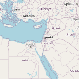
A1, Anadolu Otoyolu
3843.9 km, 43 h
| Head southeast on Ruotsinsalmenkatu | 35 m | |
| Turn right onto Kirkkokatu | 450 m | |
| Turn right onto Kotkankatu | 150 m | |
| Turn left onto Rautatienkatu (15) | 400 m | |
| Continue onto Hyväntuulentie (15) | 5.5 km | |
| Turn left | 550 m | |
| Merge left onto Valtatie 7 (7) | 25 km | |
| Continue onto Ahvenkosken silta (7) | 400 m | |
| Continue onto Ohikulkutie (7) | 15 km | |
| Continue onto Porvoon Moottoritie (7) | 20 km | |
| Continue onto Valtatie 7 (7) | 30 km | |
| Continue onto Porvoonväylä (7) | 25 km | |
| Merge left onto Lahdenväylä (4) | 6 km | |
| Continue onto Kustaa Vaasan tie | 1.5 km | |
| Continue onto Hämeentie | 150 m | |
| Keep left onto Hämeentie | 550 m | |
| Keep right onto Sturenkatu | 2 km | |
| Continue onto Helsinginkatu | 900 m | |
| Continue onto Runeberginkatu | 800 m | |
| Keep right onto Caloniuksenkatu | 250 m | |
| Turn left onto Mechelininkatu | 1.5 km | |
| Turn right towards Jätkäsaari | 250 m | |
| Go straight onto Tyynenmerenkatu | 400 m | |
| Turn left onto Rionkatu | 50 m | |
| Turn right | 800 m | |
| Make a slight left | 150 m | |
| Take the ferry Helsinki–Tallinn | 80 km | |
| Make a slight left | 150 m | |
| Turn left | 350 m | |
| Continue onto Petrooleumi | 450 m | |
| Continue slightly left onto Jüri Vilmsi | 1 km | |
| Turn right onto Konstantin Türnpu | 300 m | |
| Turn right onto Odra | 300 m | |
| Continue onto Filtri tee | 700 m | |
| Make a slight right towards Veerenni tn | 100 m | |
| Make a slight left towards Luite | 150 m | |
| Turn left onto Veskiposti | 200 m | |
| Enter the traffic circle and take the 3rd exit towards Järvevana tee | 80 m | |
| Exit the traffic circle towards Järvevana tee | 400 m | |
| Go straight onto Järvevana tee | 2.5 km | |
| Go straight towards 4: Pärnu | 300 m | |
| Make a slight right onto Pärnu mnt (4) | 1.5 km | |
| Continue onto Männiku tee (4) | 450 m | |
| Go straight onto Vabaduse pst (4) | 6 km | |
| Continue onto Pärnu mnt (4) | 1 km | |
| Make a slight right onto Veskitammi (11401) | 60 m | |
| Make a slight left to stay on Veskitammi (11401) | 150 m | |
| Make a slight right | 150 m | |
| Merge left onto Pärnu mnt (4) | 1.5 km | |
| Continue onto Tallinn — Pärnu — Ikla (4) | 100 km | |
| Continue onto Pärnu mnt (4) | 2 km | |
| Continue onto Tallinn — Pärnu — Ikla (4) | 9 km | |
| Continue onto Tallinna mnt (4) | 1.5 km | |
| Enter the traffic circle and take the 2nd exit onto Tallinna mnt (4) | 45 m | |
| Exit the traffic circle onto Tallinna mnt (4) | 600 m | |
| Continue onto Tallinn — Pärnu — Ikla (4) | 1.5 km | |
| Continue onto Tuisu (4) | 600 m | |
| Continue slightly left onto Ehitajate tee (4) | 5 km | |
| Continue onto Papiniidu (4) | 400 m | |
| Go straight onto Liivi tee (4) | 1.5 km | |
| Continue straight to stay on Liivi tee (4) | 700 m | |
| Continue left onto Riia mnt (4) | 450 m | |
| Make a slight left onto Paide mnt (59) | 50 m | |
| Turn right to stay on Riia mnt (4) | 1 km | |
| Continue onto Tallinn — Pärnu — Ikla (4) | 15 km | |
| Continue onto Riia mnt (4) | 3.5 km | |
| Continue onto Tallinn — Pärnu — Ikla (4) | 35 km | |
| Continue onto Rīga (Baltezers) — Igaunijas robeža (Ainaži) (A1) | 9 km | |
| Continue onto Pērnavas iela (A1) | 4 km | |
| Continue onto Viļņu iela (A1) | 1 km | |
| Continue onto Rīga (Baltezers) — Igaunijas robeža (Ainaži) (A1) | 550 m | |
| Continue onto Vidzemes iela (A1) | 2.5 km | |
| Continue onto Rīga (Baltezers) — Igaunijas robeža (Ainaži) (A1) | 80 km | |
| Continue onto Tallinas šoseja (A1) | 2 km | |
| Continue onto Cielaviņu iela (A1) | 250 m | |
| Continue onto Rīga (Baltezers) — Igaunijas robeža (Ainaži) (A1) | 2.5 km | |
| Continue onto A4 | 20 km | |
| Take the ramp onto A4 | 500 m | |
| Merge left onto Rīga — Daugavpils — Krāslava — Baltkrievijas robeža (Pāternieki) (A6) | 2.5 km | |
| Continue onto Ķesterciema iela (A6) | 2 km | |
| Keep right at the fork | 800 m | |
| Enter the traffic circle and take the 1st exit onto A5 | 30 m | |
| Exit the traffic circle onto A5 | 7 km | |
| Enter the traffic circle and take the 1st exit onto Rīgas apvedceļš (Salaspils — Babīte) (A5) | 50 m | |
| Exit the traffic circle onto Rīgas apvedceļš (Salaspils — Babīte) (A5) | 1.5 km | |
| Enter the traffic circle and take the 3rd exit onto P137 | 200 m | |
| Exit the traffic circle onto P137 | 4 km | |
| Take the ramp onto P137 | 200 m | |
| Merge left onto Ķekavas apvedceļš (A7) | 150 m | |
| Continue onto Rīga — Bauska — Lietuvas robeža (Grenctāle) (A7) | 20 km | |
| Continue onto Rīgas iela (A7) | 1.5 km | |
| Keep right onto Rīgas iela (A7) | 20 km | |
| Continue onto Kalna iela (A7) | 1.5 km | |
| Enter the traffic circle and take the 2nd exit onto A7 | 45 m | |
| Exit the traffic circle onto A7 | 20 km | |
| Continue onto Pasienio g. (A10) | 800 m | |
| Continue onto Via Baltica (A10) | 3.5 km | |
| Continue onto Rygos g. (A10) | 1.5 km | |
| Continue onto Bėrelės g. (A10) | 6 km | |
| Continue onto Via Baltica (A10) | 15 km | |
| Enter the traffic circle and take the 2nd exit towards Panevėžys | 40 m | |
| Exit the traffic circle towards Panevėžys | 3.5 km | |
| Continue onto Baltijos Kelio g. (A10) | 2 km | |
| Continue onto Panevėžio g. (A10) | 1 km | |
| Continue onto Via Baltica (A10) | 150 m | |
| Continue onto Baltijos Kelio g. (A10) | 7 km | |
| Continue onto Via Baltica (A10) | 400 m | |
| Continue onto Kovo 11-osios g. (A10) | 15 km | |
| Keep left towards Panevėžys | 200 m | |
| Enter the traffic circle and take the 1st exit towards Šiauliai | 30 m | |
| Exit the traffic circle towards Šiauliai | 7 km | |
| Enter Panevėžio aplinkl. and take the 2nd exit towards Šiauliai | 30 m | |
| Exit the traffic circle towards Šiauliai | 9 km | |
| Enter the traffic circle and take the 1st exit onto 195 | 20 m | |
| Exit the traffic circle onto 195 | 20 km | |
| Continue onto Pušyno g. (2008) | 4 km | |
| Continue onto Vilainiai — Šventybrastis — Krekenava (2008) | 20 km | |
| Continue onto Melioratorių g. (2008) | 3 km | |
| Continue onto Tiskūnų g. (2008) | 2 km | |
| Turn left onto 229 | 3 km | |
| Take the ramp onto Aristava — Kėdainiai — Cinkiškis (229) | 20 m | |
| Keep right towards Kaunas | 450 m | |
| Merge left onto A8 | 35 km | |
| Merge left onto A1 | 10 km | |
| Take the ramp towards A5: Marijampolė | 600 m | |
| Merge left towards Marijampolė | 600 m | |
| Take the ramp | 30 m | |
| Keep left at the fork | 250 m | |
| Merge left onto Vakarinis aplinkl. (A5) | 4.5 km | |
| Continue onto Via Baltikos kel. (A5) | 4.5 km | |
| Continue onto Baltijos g. (A5) | 5.5 km | |
| Take the ramp towards Marijampolė | 600 m | |
| Merge left onto Marijampolės g. (A5) | 550 m | |
| Continue onto Via Baltica (A5) | 35 km | |
| Continue onto Kauno g. (A5) | 5 km | |
| Continue onto Via Baltica (A5) | 30 km | |
| Continue onto Muitinės g. (A5) | 4 km | |
| Continue onto Europos g. (A5) | 5 km | |
| Continue onto Via Baltica (S61) | 1 km | |
| Continue straight | 150 m | |
| Continue straight | 300 m | |
| Continue onto Via Baltica (S61) | 250 km | |
| Continue onto Warszawska (S8) | 2 km | |
| Continue towards S8: Warszawa | 1.5 km | |
| Continue onto Trasa Bohaterów Bitwy Warszawskiej 1920 (S8) | 8 km | |
| Continue onto Kardynała Stefana Wyszyńskiego (S8) | 4 km | |
| Continue onto Marszałka Józefa Piłsudskiego (S8) | 550 m | |
| Continue onto Kardynała Stefana Wyszyńskiego (S8) | 1.5 km | |
| Continue onto Trasa Bohaterów Bitwy Warszawskiej 1920 (S8) | 10 km | |
| Continue onto Aleja Bohaterów Bitwy Warszawskiej 1920 (S8) | 1.5 km | |
| Continue onto Trasa Bohaterów Bitwy Warszawskiej 1920 (S8) | 1.5 km | |
| Continue onto Aleja Bohaterów Bitwy Warszawskiej 1920 (S8) | 3 km | |
| Continue onto Toruńska (S8) | 6 km | |
| Continue onto Most Generała Stefana Grota-Roweckiego (S8) | 700 m | |
| Continue onto Aleja Armii Krajowej (S8) | 4 km | |
| Continue onto Aleja Obrońców Grodna (S8) | 10 km | |
| Keep left towards A2: Poznań | 1 km | |
| Continue onto Autostrada Wolności (A2) | 90 km | |
| Take the ramp towards A1: Gdańsk | 550 m | |
| Keep left towards A1: Katowice | 2 km | |
| Merge left towards Katowice | 250 km | |
| Continue onto D1 | 80 km | |
| Keep left towards D35: Olomouc | 1 km | |
| Keep right towards Olomouc | 30 km | |
| Take the ramp towards Brno | 300 m | |
| Keep right towards Prostějov | 250 m | |
| Keep left towards Prostějov | 2 km | |
| Merge right onto D46 | 35 km | |
| Keep left towards Brno | 450 m | |
| Merge left onto D1 | 35 km | |
| Take the ramp | 45 m | |
| Keep left towards D 2: Bratislava | 350 m | |
| Keep right towards D2: Bratislava | 350 m | |
| Keep left towards Bratislava | 450 m | |
| Keep left at the fork | 300 m | |
| Keep left towards Bratislava (SK) | 150 m | |
| Merge left onto D2 | 100 km | |
| Continue onto D2 | 15 km | |
| Take the ramp towards D4: Žilina | 150 m | |
| Keep left towards Žilina | 500 m | |
| Keep left towards D2: Budapest | 300 m | |
| Merge left onto D2 | 9 km | |
| Continue onto M15 | 150 km | |
| Take the ramp towards M0 | 300 m | |
| Keep right towards E 60: Szeged | 1 km | |
| Keep left towards M0 | 250 m | |
| Merge left onto M0 | 30 km | |
| Take the ramp | 450 m | |
| Keep right towards E 60: Szeged | 1 km | |
| Merge left onto M5 | 150 km | |
| Take the ramp | 350 m | |
| Keep left at the fork | 400 m | |
| Merge left onto M5 | 100 m | |
| Continue onto A1 | 200 km | |
| Keep left towards A 1: Skopje | 200 km | |
| Take the ramp towards A4: Sofia (BG) | 1.5 km | |
| Continue onto A4 | 100 km | |
| Continue onto Автомагистрала Европа (A 6) | 35 km | |
| Keep left towards 8 | 15 km | |
| Enter the traffic circle and take the 3rd exit towards Видин | 150 m | |
| Exit the traffic circle towards Видин | 350 m | |
| Take the ramp on the left towards Видин | 100 m | |
| Merge left onto Околовръстен път (8) | 4 km | |
| Take exit 49 towards А 6: Варна | 1 km | |
| Merge left onto Автомагистрала Европа (A 6) | 15 km | |
| Take exit 64 towards А 1: Пловдив | 1.5 km | |
| Merge left onto Околовръстен път (1) | 8 km | |
| Take the ramp towards A 1: Пловдив | 350 m | |
| Merge left onto Автомагистрала Тракия (A 1) | 150 km | |
| Keep right towards А 4: Свиленград | 100 km | |
| Keep left towards Turkey | 500 m | |
| Continue onto Kapıkule Sınır Kapısı (D-100) | 10 km | |
| Keep left towards Lalapaşa | 150 km | |
| Take exit K-1 towards O-7: Çatalca | 1 km | |
| Keep left towards O-7: Çatalca | 2.5 km | |
| Continue towards O-7: Çatalca | 100 km | |
| Keep left onto Kuzey Marmara Otoyolu (O-7) | 4.5 km | |
| Continue onto Viyadük-29 (O-7) | 600 m | |
| Continue onto Kuzey Marmara Otoyolu (O-7) | 30 km | |
| Keep left onto Kuzey Marmara Otoyolu (O-7) | 45 km | |
| Keep left onto Kuzey Marmara Otoyolu (O-7) | 60 km | |
| Merge left onto Anadolu Otoyolu (O-4) | 250 km | |
| Continue onto Ankara Çevre Yolu | 7 km | |
| Take the ramp towards D.140: Şehir Merkezi | 900 m | |
| Keep left towards Ayaş | 30 m | |
| Keep left towards Eskişehir | 200 m | |
| Keep left towards Ulus | 150 m | |
| Continue onto Ankara-Nallıhan yolu (D140) | 1 km | |
| Continue onto Ankara-Ayaş yolu | 2.5 km | |
| Continue onto Ankara-Ayaş Yolu | 250 m | |
| Take the ramp | 700 m | |
| Make a slight right | 800 m | |
| Merge left onto Fatih Sultan Mehmet Bulvarı (D750) | 15 km | |
| Continue onto İstanbul Caddesi (D750) | 1 km | |
| Keep left onto İstanbul Caddesi | 600 m | |
| Keep left onto İstanbul Caddesi | 200 m | |
| Continue onto İstiklal Cd. | 450 m | |
| Turn right onto Atatürk Bulvarı | 800 m | |
| Make a slight right to stay on Atatürk Bulvarı | 150 m | |
| Keep right onto Altınsoy Caddesi | 80 m | |
| Turn left | 150 m | |
| Go straight onto Celal Bayar Bulvarı | 200 m | |
| You have arrived at your destination, on the right | 0 m |
From
To
Distance:
| Cities | Distance |
|---|---|
| Kotka, Kymenlaakso, Finland to Istanbul, Istanbul, Turkey | 1,346.81 mi (2,167.47 km) |
| Kotka, Kymenlaakso, Finland to London, Westminster, United Kingdom | 1,202.89 mi (1,935.86 km) |
| Kotka, Kymenlaakso, Finland to Paris, Paris, France | 1,255.52 mi (2,020.56 km) |
| Kotka, Kymenlaakso, Finland to Madrid, Madrid, Spain | 1,900.31 mi (3,058.25 km) |
| Kotka, Kymenlaakso, Finland to Ankara, Ankara, Turkey | 1,441.44 mi (2,319.77 km) |
12345
 Log in with Google