Distance Calculator

A3, A 3

3607.2 km, 38 h

Head southeast on 15 Temmuz Şehitleri Caddesi100 m
Make a U-turn and continue on 15 Temmuz Şehitleri Caddesi250 m
Continue onto Macar Kardeşler Caddesi500 m
Continue onto Fevzipaşa Caddesi700 m
Turn left onto Mütercim Asım Caddesi150 m
Continue onto Akşemsettin Caddesi500 m
Turn right55 m
Go straight onto Adnan Menderes Vatan Bulvarı1 km
Continue towards Çevreyolu9 km
Continue towards O-3: İstanbul Havalimanı250 km
Continue onto Edirne - Kapıkule Yolu (D-100)10 km
Continue onto Автомагистрала Марица (A 4)300 m
Keep left onto Автомагистрала Марица (A 4)100 km
Merge left onto Автомагистрала Тракия (A 1)150 km
Take exit 0 towards 1: Калотина600 m
Merge left onto Околовръстен път (1)8 km
Take the ramp towards А 6: Калотина350 m
Merge left onto Бул. Ботевградско шосе (1)700 m
Continue towards А 6: Калотина60 km
Continue onto A4100 km
Keep left towards A1: Београд / Beograd550 m
Merge left onto A160 km
Continue onto A1150 km
Keep left towards Budapest10 km
Continue onto Кијевски поток (A1)550 m
Continue onto Обилазница око Београда (A1)20 km
Keep left towards A 3: Zagreb (HR)2.5 km
Merge right onto Аутопут (A3)90 km
Take the ramp350 m
Keep right at the fork150 m
Merge left onto A3300 km
Take the ramp towards A2: Maribor250 m
Keep left towards A2: Maribor8 km
Continue onto Most Krapina (A2)200 m
Continue onto Zagrebačka obilaznica (A2)40 km
Continue onto Brezovica (A2)550 m
Continue onto Puhi (A2)10 km
Continue onto A435 km
Keep right towards (A) (H)700 m
Merge left onto A125 km
Continue onto Pyhrn Autobahn (A9)60 km
Keep left towards Salzburg150 km
Continue onto Innkreis Autobahn (A8)15 km
Keep left towards A8: Passau60 km
Continue onto A 3150 km
Take the ramp towards A 93: Hof150 m
Keep left towards A 93: München600 m
Keep left towards A 3100 km
Take the ramp towards B 4: Erlangen-Tennelohe250 m
Keep left towards B 4: Nürnberg400 m
Keep left towards A 3: Würzburg200 km
Keep left towards Köln9 km
Take the ramp towards A 66: Wiesbaden300 m
Keep left towards A 66: Wiesbaden350 m
Keep left towards A 3: Köln450 m
Merge left onto A 370 km
Take the ramp towards B 255: Montabaur70 m
Continue towards B 49: Montabaur450 m
Continue straight450 m
Keep left towards A 48: Köln450 m
Keep left towards A 3: Dreieck Dernbach500 m
Merge left onto A 380 km
Take the ramp towards A 4: Aachen1.5 km
Merge left onto A 410 km
Keep right onto A 4500 m
Take the ramp towards A 4: Aachen300 m
Keep left towards A 4: Aachen450 m
Keep left towards A 4: Aachen150 m
Merge left onto A 460 km
Keep right towards Antwerpen10 km
Continue onto A7625 km
Continue onto E31490 km
Keep right towards E40: Brussel1.5 km
Merge left onto E4010 km
Take the ramp towards E411500 m
Keep right towards E40: Gent350 m
Merge left onto R015 km
Take the ramp towards E40: Gent1 km
Keep left towards Oostende900 m
Merge left onto E4090 km
Keep left towards Calais40 km
Continue onto L'Européenne (A 16)55 km
Take the ramp towards Tunnel sous la Manche250 m
Keep left towards Tunnel sous la Manche800 m
Keep right at the fork100 m
Make a slight left55 m
Make a slight right25 m
Keep right at the fork550 m
Keep left at the fork100 m
Keep right at the fork15 m
Keep left at the fork250 m
Keep right at the fork90 m
Keep left at the fork25 m
Turn left10 m
Keep right at the fork200 m
Turn left350 m
Turn right100 m
Make a slight left15 m
Take the ferry Le Shuttle60 km
Continue slight right150 m
Make a slight right onto Over Bridge 3900 m
Keep left at the fork1.5 km
Take the ramp towards London250 m
Keep right towards London50 km
Take the ramp on the left towards A20: Maidstone450 m
Keep left towards Maidstone350 m
Exit the traffic circle towards M20: Ashford450 m
Enter Cobtree Roundabout and take the 1st exit45 m
Exit the traffic circle250 m
Keep left at the fork200 m
Merge right onto A2293.5 km
Take the ramp300 m
Enter Lord Lees Roundabout and take the 3rd exit onto A229200 m
Exit the traffic circle onto A229350 m
Enter Taddington Roundabout and take the 1st exit onto M215 m
Exit the traffic circle onto M2600 m
Keep right onto M29 km
Continue onto Watling Street (A2)10 km
Continue onto Dartford Bypass (A2)3 km
Take the ramp on the left towards A282: Dartford Crossing1.5 km
Merge right onto Canterbury Way (A282)2.5 km
Keep left onto Canterbury Way (A282)4.5 km
Continue towards M25: (M1125 km
Take the ramp on the left towards M11 (S): London (NE & C)800 m
Keep right towards M11: Stansted1 km
Merge right onto M1120 km
Keep right onto M1120 km
Keep right onto M1125 km
Merge right onto Huntingdon Road (A14)20 km
Continue onto A14100 m
Take the ramp on the left onto A14200 km
Keep right onto A1(M)55 km
Keep right towards A1(M): The North35 km
Take the ramp on the left towards A6055: Richmond500 m
Enter Scotch Corner and take the 2nd exit towards Brough100 m
Exit the traffic circle towards Brough10 km
Continue onto A664 km
Continue onto A6660 km
Enter Kemplay Bank Roundabout and take the 2nd exit towards Keswick150 m
Exit the traffic circle towards Keswick1 km
Enter Skirsgill Roundabout and take the 3rd exit towards M6(N): Carlisle300 m
Exit the traffic circle towards M6(N): Carlisle350 m
Merge right onto M645 km
Continue onto A74(M)80 km
Continue onto M7430 km
Take the ramp on the left onto M74550 m
Enter Canderside Toll and take the 4th exit onto Swinhill Road (A71)200 m
Exit the traffic circle onto Swinhill Road (A71)800 m
Continue onto Ayr Road (A71)3 km
Make a slight left onto A7130 m
Enter the traffic circle and take the 2nd exit onto Cornsilloch Brae (A71)35 m
Exit the traffic circle onto Cornsilloch Brae (A71)450 m
Enter the traffic circle and take the 1st exit onto Horsley Brae (A71)80 m
Exit the traffic circle onto Horsley Brae (A71)2 km
Continue onto Main Street (A71)900 m
Continue slightly right onto Overtown Road (A71)700 m
Enter the traffic circle and take the 1st exit onto Wishaw Road (A721)3.5 m
Exit the traffic circle onto Wishaw Road (A721)550 m
Continue onto Stewarton Street (A721)1 km
Turn right onto Kirk Road (A722)100 m
You have arrived at your destination0 m
From
    To

      Distance: 1,794.20 mi (2,887.49 km)

      Driving route: 2241.43 mi (3607.23 km).

      Driving time: 37h 49 min

      Distance from Wishaw to Istanbul

      The shortest distance (air line) between Wishaw and Istanbul is 1,794.20mi (2,887.49 km)

      The shortest route between Wishaw and Istanbul is 2241.43 mi (3607.23 km) according to the route planner. The driving time is approx. 37 h 49 m

      How far is it between Wishaw and Istanbul.

      Wishaw is located in North Lanarkshire, United Kingdomcountry within 55° 46' 27.12" N -4° 4' 54.12" W (55.7742, -3.9183) coordinates. The local time in Wishaw is 23:16 (08.10.2025)

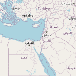
      Istanbul is located in Istanbul, Turkeycountry within 41° 0' 48.96" N 28° 57' 18" E (41.0136, 28.9550) coordinates. The local time in Istanbul is 02:16 (09.10.2025)

      The calculated flying distance from Wishaw to Istanbul is 1,794.20miles which is equal to 2,887.49 km.

      If you want to go by car, the driving driving distance between Wishaw and Istanbul is 2241.43 miles (3607.23 km). If you ride your car with an average speef of 112 kilometers/hour (70 miles/h), travel time will be 32 hours 12 minutes.Please check the avg.speed travel time on the right for various options

      Estimated Travel Time Between Wishaw and Istanbul

      Average speedTravel Time
      30 mph (48 km/h)74 hours 43 minutes
      40 mph (64 km/h)56 hours 2 minutes
      50 mph (80 km/h)44 hours 50 minutes
      60 mph (67 km/h)37 hours 21 minutes
      70 mph (112 km/h)32 hours 1 minutes
      75 mph (120 km/h)29 hours 53 minutes

      Wishaw, North Lanarkshire, United Kingdom

      Related Distances from Wishaw

      CitiesDistance
      Wishaw to Glasgow14.21 mi (22.86 km)
      Wishaw to Edinburgh30.86 mi (49.66 km)
      Wishaw to Newcastle105.93 mi (170.48 km)
      Wishaw to Belfast113.66 mi (182.91 km)
      Wishaw to Bradford161.44 mi (259.81 km)
      Wishaw to Bolton162.98 mi (262.29 km)
      Wishaw to Leeds165.83 mi (266.87 km)
      Wishaw to Liverpool167.67 mi (269.84 km)
      Wishaw to Manchester172.09 mi (276.94 km)
      Wishaw to Stockport178.13 mi (286.68 km)
      Wishaw to Sheffield192.21 mi (309.34 km)
      Wishaw to Kingston upon Hull200.22 mi (322.22 km)
      Wishaw to Stoke-on-Trent203.98 mi (328.27 km)
      Wishaw to Nottingham224.47 mi (361.26 km)
      Wishaw to Birmingham241.77 mi (389.09 km)
      Wishaw to Leicester244.38 mi (393.28 km)
      Wishaw to Coventry252.17 mi (405.83 km)
      Wishaw to Caerdydd298.12 mi (479.78 km)
      Wishaw to Bristol303.38 mi (488.24 km)
      Wishaw to Reading321.90 mi (518.04 km)
      Wishaw to Ipswich329.23 mi (529.84 km)
      Wishaw to London333.09 mi (536.06 km)
      Wishaw to Southampton352.16 mi (566.74 km)
      Wishaw to Portsmouth362.57 mi (583.50 km)
      Wishaw to Worthing372.54 mi (599.55 km)

      Istanbul, Istanbul, Turkey

      Related Distances to Istanbul

      CitiesDistance
      Erzurum to Istanbul651.68 mi (1,048.78 km)
      Esenler to Istanbul3.65 mi (5.88 km)
      Kagithane to Istanbul4.07 mi (6.55 km)
      Bagcilar to Istanbul5.34 mi (8.59 km)
      Kucukcekmece to Istanbul8.14 mi (13.09 km)
      Kartal to Istanbul15.06 mi (24.23 km)
      Esenyurt to Istanbul15.65 mi (25.19 km)
      Pendik to Istanbul17.48 mi (28.14 km)
      Bursa to Istanbul57.58 mi (92.67 km)
      Yildirim to Istanbul62.79 mi (101.05 km)
      Eskisehir to Istanbul118.70 mi (191.03 km)
      Izmir to Istanbul203.50 mi (327.50 km)
      Ankara to Istanbul217.96 mi (350.77 km)
      Cankaya to Istanbul219.86 mi (353.83 km)
      Denizli to Istanbul224.44 mi (361.21 km)
      Selcuklu to Istanbul287.09 mi (462.03 km)
      Konya to Istanbul287.56 mi (462.78 km)
      Antalya to Istanbul300.22 mi (483.16 km)
      Kayseri to Istanbul380.74 mi (612.75 km)
      Samsun to Istanbul384.23 mi (618.36 km)
      Mersin to Istanbul421.68 mi (678.62 km)
      Adana to Istanbul439.94 mi (708.01 km)
      Seyhan to Istanbul441.18 mi (710.02 km)
      Gaziantep to Istanbul527.75 mi (849.33 km)
      Akcaabat to Istanbul552.01 mi (888.38 km)