Distance Calculator

I 40, Purple Heart Trail

1943.3 km, 20 h 41 min

Head south on East Street Northeast250 m
Turn left onto East BJ Tunnel Boulevard250 m
Continue slightly right onto H Street Northeast600 m
Turn right onto 4th Avenue Northeast25 m
Turn left onto H Street Northeast600 m
Continue onto H Street Southeast400 m
Turn left onto East Steve Owens Boulevard (OK 10)1.5 km
Take the ramp on the right250 m
Keep left towards Cash Only250 m
Keep right towards I 44 West: Tulsa400 m
Merge left onto Will Rogers Turnpike (I 44)100 km
Keep right towards I 44 West: Tulsa8 km
Keep left towards I 44 West: Sapulpa20 km
Keep left onto Skelly Bypass (I 44)2 km
Continue onto Governor Roy Joseph Turner Turnpike (I 44)150 km
Continue towards Kilpatrick Turnpike West40 km
Take the ramp towards I 40 West: Yukon1 km
Keep left towards I 40 West: Amarillo250 m
Merge left onto Korean War Veterans Memorial Highway (I 40)90 km
Continue onto Senator Ed Berrong Memorial Highway (I 40)4 km
Continue onto Korean War Veterans Memorial Highway (I 40)40 km
Continue onto Great Western Cattle Trail (I 40)15 km
Continue onto Korean War Veterans Memorial Highway (I 40)1500 km
Take the ramp towards Stockton Hill Road600 m
Turn right onto Stockton Hill Road (CR 20)4.5 km
Turn right onto College Drive550 m
Turn right onto Thompson Avenue2 km
Turn left onto North Bank Street350 m
Turn right onto Potter Avenue200 m
You have arrived at your destination, on the left0 m

I 40, Purple Heart Trail

1974.1 km, 21 h 60 min

Head south on East Street Northeast250 m
Turn left onto East BJ Tunnel Boulevard250 m
Continue slightly right onto H Street Northeast600 m
Turn right onto 4th Avenue Northeast25 m
Turn left onto H Street Northeast600 m
Continue onto H Street Southeast400 m
Turn left onto East Steve Owens Boulevard (OK 10)1.5 km
Take the ramp on the right250 m
Keep left towards Cash Only250 m
Keep right towards I 44 West: Tulsa400 m
Merge left onto Will Rogers Turnpike (I 44)100 km
Keep right towards I 44 West: Tulsa8 km
Keep right towards I 244 West: Sand Springs15 km
Keep left towards US 64 West: Sand Springs25 km
Continue onto Keystone Expressway (US 64)6 km
Continue onto Jerald Warden Memorial Highway (US 64)2 km
Continue onto Keystone Expressway (US 64)8 km
Continue onto Cimarron Turnpike (US 412)50 km
Keep left onto Cimarron Turnpike (US 412)45 km
Continue onto Norma A. Lamb Highway (US 64)40 km
Continue onto East Owen K Garriott Road (US 64)20 km
Continue onto Trooper Chris Van Krevelen Memorial Highway (US 60)10 km
Continue onto Lahoma Road (US 60)500 m
Continue onto Trooper Chris Van Krevelen Memorial Highway (US 60)30 km
Continue onto US 604.5 km
Continue onto OK 870 km
Continue onto Southwest 6th Street (US 412)20 km
Take the ramp onto US 18350 m
Merge left onto Northwest Highway (US 183)20 km
Continue onto US 183200 km
Turn left onto Southeast 2nd Street (US 54)600 m
Continue onto Southwest 2nd Street (US 54)15 km
Continue onto 3rd Street (US 54)2 km
Continue onto Jack Vernon Begley Memorial Highway (US 54)100 km
Continue onto Denver Avenue (US 54)600 m
Turn right onto West 7th Street (US 54)70 km
Continue onto Bell Street (US 54)80 km
Take the ramp onto US 54700 m
Merge left onto I 401000 km
Take the ramp towards Stockton Hill Road600 m
Turn right onto Stockton Hill Road (CR 20)4.5 km
Turn right onto College Drive550 m
Turn right onto Thompson Avenue2 km
Turn left onto North Bank Street350 m
Turn right onto Potter Avenue200 m
You have arrived at your destination, on the left0 m
From
    To

      Distance: 1,072.79 mi (1,726.48 km)

      Driving route: 1207.49 mi (1943.27 km).

      Driving time: 20h 40 min

      Distance from Miami to New Kingman-Butler

      The shortest distance (air line) between Miami and New Kingman-Butler is 1,072.79mi (1,726.48 km)

      The shortest route between Miami and New Kingman-Butler is 1207.49 mi (1943.27 km) according to the route planner. The driving time is approx. 20 h 40 m

      How far is it between Miami and New Kingman-Butler.

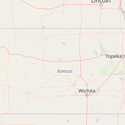
      Miami is located in Oklahoma, United Statescountry within 36° 53' 16.08" N -95° 7' 44.04" W (36.8878, -94.8711) coordinates. The local time in Miami is 00:36 (11.08.2025)

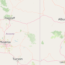
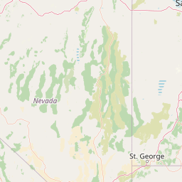
      New Kingman-Butler is located in Arizona, United Statescountry within 35° 15' 52.2" N -115° 59' 27.24" W (35.2645, -114.0091) coordinates. The local time in New Kingman-Butler is 23:36 (10.08.2025)

      The calculated flying distance from Miami to New Kingman-Butler is 1,072.79miles which is equal to 1,726.48 km.

      If you want to go by car, the driving driving distance between Miami and New Kingman-Butler is 1207.49 miles (1943.27 km). If you ride your car with an average speef of 112 kilometers/hour (70 miles/h), travel time will be 17 hours 21 minutes.Please check the avg.speed travel time on the right for various options

      Estimated Travel Time Between Miami and New Kingman-Butler

      Average speedTravel Time
      30 mph (48 km/h)40 hours 15 minutes
      40 mph (64 km/h)30 hours 11 minutes
      50 mph (80 km/h)24 hours 9 minutes
      60 mph (67 km/h)20 hours 7 minutes
      70 mph (112 km/h)17 hours 15 minutes
      75 mph (120 km/h)16 hours 6 minutes

      Miami, Oklahoma, United States

      Related Distances from Miami

      CitiesDistance
      Miami to Atlanta626.93 mi (1,008.95 km)
      Miami to Detroit731.33 mi (1,176.96 km)
      Miami to Tampa948.51 mi (1,526.48 km)
      Miami to Washington981.80 mi (1,580.06 km)
      Miami to Phoenix996.88 mi (1,604.32 km)
      Miami to Baltimore1,004.86 mi (1,617.17 km)
      Miami to Philadelphia1,087.17 mi (1,749.63 km)
      Miami to Las Vegas1,130.59 mi (1,819.51 km)
      Miami to Brooklyn1,153.65 mi (1,856.62 km)
      Miami to Miami1,153.74 mi (1,856.77 km)
      Miami to New York1,155.27 mi (1,859.23 km)
      Miami to Queens1,162.32 mi (1,870.58 km)
      Miami to Riverside1,281.52 mi (2,062.41 km)
      Miami to San Diego1,289.10 mi (2,074.60 km)
      Miami to Boston1,315.70 mi (2,117.41 km)
      Miami to Los Angeles1,334.20 mi (2,147.19 km)
      Miami to San Francisco1,510.77 mi (2,431.35 km)
      Miami to Portland1,552.70 mi (2,498.83 km)
      Miami to Seattle1,576.02 mi (2,536.36 km)
      Miami to St. Louis280.02 mi (450.65 km)
      Miami to Dallas302.60 mi (486.99 km)
      Miami to Houston491.59 mi (791.14 km)
      Miami to Chicago513.71 mi (826.74 km)
      Miami to Minneapolis564.19 mi (907.97 km)
      Miami to Denver577.11 mi (928.77 km)

      New Kingman-Butler, Arizona, United States

      Related Distances to New Kingman-Butler

      CitiesDistance
      Portland to New Kingman-Butler841.76 mi (1,354.68 km)
      Seattle to New Kingman-Butler954.90 mi (1,536.77 km)
      Dallas to New Kingman-Butler1,000.64 mi (1,610.38 km)
      Houston to New Kingman-Butler1,146.73 mi (1,845.49 km)
      Las Vegas to New Kingman-Butler97.18 mi (156.39 km)
      Minneapolis to New Kingman-Butler1,278.97 mi (2,058.30 km)
      St. Louis to New Kingman-Butler1,328.80 mi (2,138.49 km)
      Chicago to New Kingman-Butler1,486.22 mi (2,391.84 km)
      Atlanta to New Kingman-Butler1,681.44 mi (2,706.01 km)
      Detroit to New Kingman-Butler1,724.09 mi (2,774.66 km)
      Phoenix to New Kingman-Butler160.14 mi (257.72 km)
      Tampa to New Kingman-Butler1,914.71 mi (3,081.43 km)
      Washington to New Kingman-Butler2,040.42 mi (3,283.74 km)
      Baltimore to New Kingman-Butler2,059.80 mi (3,314.92 km)
      Miami to New Kingman-Butler2,103.77 mi (3,385.68 km)
      Philadelphia to New Kingman-Butler2,135.03 mi (3,436.01 km)
      Brooklyn to New Kingman-Butler2,194.54 mi (3,531.78 km)
      New York to New Kingman-Butler2,195.66 mi (3,533.57 km)
      Queens to New Kingman-Butler2,202.09 mi (3,543.92 km)
      Boston to New Kingman-Butler2,336.75 mi (3,760.64 km)
      Riverside to New Kingman-Butler213.24 mi (343.17 km)
      San Diego to New Kingman-Butler244.97 mi (394.25 km)
      Los Angeles to New Kingman-Butler262.15 mi (421.89 km)
      San Francisco to New Kingman-Butler498.86 mi (802.84 km)
      Denver to New Kingman-Butler588.70 mi (947.42 km)