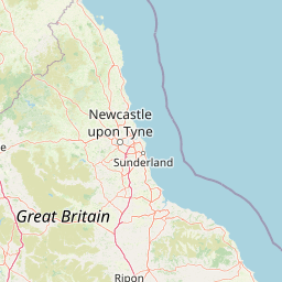
| Head southwest | 30 m |
| Turn right onto South End (A1138) | 200 m |
| Merge right onto Haven Bridge (A16) | 60 m |
| Continue onto John Adams Way (A16) | 200 m |
| Enter the traffic circle and take the 2nd exit onto A52 | 35 m |
| Exit the traffic circle onto A52 | 2.5 km |
| Continue onto Boardsides (A1121) | 150 m |
| Enter the traffic circle and take the 1st exit onto Boardsides (A1121) | 20 m |
| Exit the traffic circle onto Boardsides (A1121) | 3.5 km |
| Continue onto Lineside (A1121) | 5.5 km |
| Turn right onto A17 | 20 km |
| Enter Holdingham Roundabout and take the 3rd exit onto Newark Road (A17) | 150 m |
| Exit the traffic circle onto Newark Road (A17) | 7 km |
| Continue onto Heath Road (A17) | 2.5 km |
| Continue onto Sleaford Road (A17) | 10 km |
| Go straight onto Beckingham Bypass (A17) | 1.5 km |
| Continue onto Sleaford Road (A17) | 2.5 km |
| Enter the traffic circle and take the 2nd exit onto A17 | 40 m |
| Exit the traffic circle onto A17 | 3 km |
| Enter the traffic circle and take the 2nd exit onto A17 | 50 m |
| Exit the traffic circle onto A17 | 250 m |
| Enter the traffic circle and take the 2nd exit onto Lincoln Road (A46) | 40 m |
| Exit the traffic circle onto Lincoln Road (A46) | 350 m |
| Enter the traffic circle and take the 2nd exit onto Newark Bypass (A46) | 55 m |
| Exit the traffic circle onto Newark Bypass (A46) | 2.5 km |
| Enter the traffic circle and take the 2nd exit onto Newark Bypass (A46) | 50 m |
| Exit the traffic circle onto Newark Bypass (A46) | 2.5 km |
| Enter the traffic circle and take the 2nd exit onto A46 | 150 m |
| Exit the traffic circle onto A46 | 15 km |
| Take the ramp on the left | 600 m |
| Enter Bingham Interchange and take the 4th exit onto A52 | 350 m |
| Exit the traffic circle onto A52 | 8 km |
| Enter Gamston Roundabout and take the 1st exit onto Gamston Lings Bar Road (A52) | 3.5 m |
| Exit the traffic circle onto Gamston Lings Bar Road (A52) | 4 km |
| Enter Wheatcroft Island and take the 2nd exit onto Wheatcroft Island (A52) | 100 m |
| Exit the traffic circle onto Wheatcroft Island (A52) | 2 km |
| Enter Nottingham Knight and take the 2nd exit onto Clifton Boulevard (A52) | 60 m |
| Exit the traffic circle onto Clifton Boulevard (A52) | 2 km |
| Take the ramp on the left towards Clifton | 450 m |
| Enter the traffic circle and take the 2nd exit onto Remembrance Way | 45 m |
| Exit the traffic circle onto Remembrance Way | 350 m |
| Merge right onto Remembrance Way (A453) | 450 m |
| Enter Farnbourgh Road Roundabout and take the 2nd exit onto Remembrance Way (A453) | 55 m |
| Exit the traffic circle onto Remembrance Way (A453) | 1.5 km |
| Enter Crusader Roundabout and take the 2nd exit onto Remembrance Way (A453) | 45 m |
| Exit the traffic circle onto Remembrance Way (A453) | 1 km |
| Enter Mill Hill Roundabout and take the 2nd exit onto Remembrance Way (A453) | 80 m |
| Exit the traffic circle onto Remembrance Way (A453) | 9 km |
| Keep right at the fork | 80 m |
| Keep left onto A50 | 8 km |
| Keep right onto A50 | 25 km |
| Enter the traffic circle and take the 2nd exit onto A50 | 90 m |
| Exit the traffic circle onto A50 | 8 km |
| Enter the traffic circle and take the 2nd exit onto A50 | 80 m |
| Exit the traffic circle onto A50 | 1.5 km |
| Enter McDonalds Roundabout and take the 2nd exit onto A50 | 50 m |
| Exit the traffic circle onto A50 | 15 km |
| Enter the traffic circle and take the 1st exit onto A50 | 10 m |
| Exit the traffic circle onto A50 | 2 km |
| Take the ramp on the left towards A521: Blythe Bridge | 250 m |
| Enter the traffic circle and take the 2nd exit | 70 m |
| Exit the traffic circle | 300 m |
| Merge right onto Uttoxeter Road (A50) | 4.5 km |
| Take the ramp on the left | 400 m |
| Enter Heron Cross Roundabout and take the 2nd exit onto Victoria Place Link (A50) | 150 m |
| Exit the traffic circle onto Victoria Place Link (A50) | 700 m |
| Enter the traffic circle and take the 1st exit onto King Street (A50) | 9 m |
| Exit the traffic circle onto King Street (A50) | 250 m |
| Enter the traffic circle and take the 2nd exit onto City Road (A5007) | 25 m |
| Exit the traffic circle onto City Road (A5007) | 1 km |
| Enter the traffic circle and take the 1st exit onto City Road (A5007) | 9 m |
| Exit the traffic circle onto City Road (A5007) | 250 m |
| Take the ramp | 250 m |
| Keep right at the fork | 200 m |
| Merge right onto Queensway (A500) | 15 km |
| Enter Barthomley Interchange and take the 2nd exit onto A500 | 150 m |
| Exit the traffic circle onto A500 | 3.5 km |
| Enter Meremoor Moss Roundabout and take the 2nd exit onto Shavington Bypass (A500) | 70 m |
| Exit the traffic circle onto Shavington Bypass (A500) | 2 km |
| Enter Weston Gate Roundabout and take the 1st exit onto Shavington Bypass (A500) | 100 m |
| Exit the traffic circle onto Shavington Bypass (A500) | 2 km |
| Enter the traffic circle and take the 2nd exit onto Shavington Bypass (A500) | 45 m |
| Exit the traffic circle onto Shavington Bypass (A500) | 3.5 km |
| Enter Cheerbrook Roundabout and take the 3rd exit onto Nantwich Bypass (A51) | 100 m |
| Exit the traffic circle onto Nantwich Bypass (A51) | 900 m |
| Enter Peacock Roundabout and take the 2nd exit onto Nantwich Bypass (A51) | 50 m |
| Exit the traffic circle onto Nantwich Bypass (A51) | 1.5 km |
| Enter Alvaston Roundabout and take the 2nd exit onto Nantwich Bypass (A51) | 40 m |
| Exit the traffic circle onto Nantwich Bypass (A51) | 800 m |
| Enter Reaseheath Roundabout and take the 2nd exit onto Millstone Lane (A51) | 70 m |
| Exit the traffic circle onto Millstone Lane (A51) | 2.5 km |
| Turn right onto Chester Road (A51) | 3.5 km |
| Continue onto Nantwich Road (A51) | 800 m |
| Enter the traffic circle and take the 2nd exit onto Nantwich Road (A51) | 40 m |
| Exit the traffic circle onto Nantwich Road (A51) | 7 km |
| Go straight onto Tarporley Bypass (A49) | 2 km |
| Enter the traffic circle and take the 1st exit onto Rode Street (A51) | 8 m |
| Exit the traffic circle onto Rode Street (A51) | 1 km |
| Continue onto High Street (A51) | 1.5 km |
| Continue onto Duddon Road (A51) | 1 km |
| Continue onto Tarporley Road (A51) | 2 km |
| Continue onto Tarvin Bypass (A51) | 2 km |
| Enter Tarvin Roundabout and take the 1st exit onto Holme Street (A51) | 8 m |
| Exit the traffic circle onto Holme Street (A51) | 1 km |
| Continue onto Tarvin Road (A51) | 3.5 km |
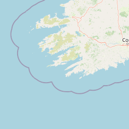
| Enter Vicars Cross and take the 1st exit towards A55: NORTH WALES | 15 m |
| Exit the traffic circle towards A55: NORTH WALES | 400 m |
| Merge right towards A55: NORTH WALES | 10 km |
| Continue onto Gwibffordd Gogledd Cymru / North Wales Expressway (A55) | 70 km |
| Enter Puffin Roundabout and take the 2nd exit onto Gwibffordd Gogledd Cymru / North Wales Expressway (A55) | 40 m |
| Exit the traffic circle onto Gwibffordd Gogledd Cymru / North Wales Expressway (A55) | 4.5 km |
| Enter Llanfairfechan Roundabout and take the 2nd exit onto Gwibffordd Gogledd Cymru / North Wales Expressway (A55) | 40 m |
| Exit the traffic circle onto Gwibffordd Gogledd Cymru / North Wales Expressway (A55) | 50 km |
| Enter Kingsland Roundabout and take the 3rd exit onto Victoria Road (A55) | 80 m |
| Exit the traffic circle onto Victoria Road (A55) | 200 m |
| Turn right onto London Road (A55) | 150 m |
| Turn left onto Llanfawr Road (A55) | 100 m |
| Enter the traffic circle and take the 1st exit towards Ferry | 25 m |
| Exit the traffic circle towards Ferry | 40 m |
| Make a slight left | 1 km |
| Keep right at the fork | 500 m |
| Turn right | 200 m |
| Take the ferry Dublin - Holyhead | 100 km |
| Continue straight | 200 m |
| Make a slight left | 20 m |
| Keep right at the fork | 250 m |
| Turn left onto Tolka Quay Road | 300 m |
| Enter the traffic circle and take the 2nd exit onto Tolka Quay Road | 25 m |
| Exit the traffic circle onto Tolka Quay Road | 800 m |
| Enter the traffic circle and take the 1st exit onto Tolka Quay Road | 15 m |
| Exit the traffic circle onto Tolka Quay Road | 200 m |
| Turn right | 200 m |
| Continue left onto Promenade Road | 500 m |
| Take the ramp on the right towards M50 | 200 m |
| Merge right onto Dublin Tunnel (M50) | 60 m |
| Keep right onto Dublin Tunnel (M50) | 5 km |
| Continue onto Airport Motorway (M50) | 1.5 km |
| Keep left onto M50 | 15 km |
| Take the ramp on the left towards R110: City Centre | 35 m |
| Keep right towards R110: City Centre | 1 km |
| Merge left onto Naas Road (N7) | 20 km |
| Continue onto Naas Bypass (M7) | 7 km |
| Continue onto Newbridge Bypass (M7) | 5 km |
| Keep right onto Newbridge Bypass (M7) | 6 km |
| Continue onto The Curragh Motorway (M7) | 2 km |
| Continue onto Kildare Bypass (M7) | 10 km |
| Continue onto Monasterevin Bypass (M7) | 20 km |
| Continue onto Portlaoise Bypass (M7) | 10 km |
| Continue onto Portlaoise to Castletown Motorway (M7) | 15 km |
| Keep right onto Portlaoise to Castletown Motorway (M7) | 10 km |
| Continue onto Castletown to Nenagh Motorway (M7) | 35 km |
| Continue onto Nenagh Bypass (M7) | 10 km |
| Continue onto Nenagh to Limerick Motorway (M7) | 25 km |
| Continue onto Limerick Southern Ring Road (M7) | 8 km |
| Take the ramp on the left towards M20: Cork | 600 m |
| Merge right onto Limerick to Patrickswell Motorway (M20) | 9 km |
| Merge left onto Patrickswell to Adare Carriageway (N21) | 3.5 km |
| Enter the traffic circle and take the 2nd exit onto N21 | 25 m |
| Exit the traffic circle onto N21 | 7 km |
| Enter the traffic circle and take the 1st exit onto N21 | 55 m |
| Exit the traffic circle onto N21 | 20 km |
| Enter the traffic circle and take the 3rd exit onto N21 | 35 m |
| Exit the traffic circle onto N21 | 40 km |
| Enter the traffic circle and take the 2nd exit onto Castleisland Bypass (N21) | 40 m |
| Exit the traffic circle onto Castleisland Bypass (N21) | 3.5 km |
| Enter the traffic circle and take the 2nd exit towards Killarney | 45 m |
| Exit the traffic circle towards Killarney | 1.5 km |
| Enter the traffic circle and take the 2nd exit towards Killarney | 70 m |
| Exit the traffic circle towards Killarney | 8 km |
| Turn left onto Main Street (N22) | 350 m |
| Turn right onto R561 | 3.5 km |
| Turn left onto R561 | 8 km |
| Continue onto N70 | 2.5 km |
| Turn left onto N70 | 50 m |
| Turn right onto N70 | 600 m |
| Enter the traffic circle and take the 2nd exit onto N70 | 30 m |
| Exit the traffic circle onto N70 | 6 km |
| Turn right onto N70 | 450 m |
| Turn left onto Iveragh Road (N70) | 7 km |
| Go straight onto N70 | 40 km |
| Turn right onto R565 | 10 km |
| Keep right onto R565 | 1 km |
| Turn left | 1.5 km |
| Make a slight left | 600 m |
| Continue straight | 1.5 km |
| Turn right | 350 m |
| You have arrived at your destination | 0 m |


 Log in with Google